Press Releases
IMMEDIATE RELEASE
April 12, 2023
Contact: (212) 839-4850, press@dot.nyc.gov
NYC DOT to Test New Technology to Improve Street Safety by Better Measuring and Analyzing Transportation Uses on NYC Streets
The first street activity sensors have been installed on 12 light poles along a variety of corridors to allow more accurate assessments and to better inform street redesigns
The sensors replace inefficient and time-consuming manual traffic counts
New York — New York City Department of Transportation Commissioner Ydanis Rodriguez announced today that the agency has undertaken an innovative pilot program to use advanced technology to improve street safety by better measuring transportation uses on New York City streets. The pilot, using technology created by Viva, has placed street activity sensors at 12 locations around New York City to collect data and generate detailed reports that will allow planners to better understand the uses of city streets – and inform future street redesigns.
“From the police department to City Hall, I have dedicated so much of my career in public service to using modern technology to make government operate more effectively and most efficiently for New Yorkers. And this street activity sensor technology will allow us to make our streets safer more quickly,” said New York City Mayor Eric Adams. “This technology has the potential to save time, money, and lives. We will be monitoring its effectiveness closely and deploying it strategically to understand how we can best maximize its impact.”
“Understanding how and when our streets are used is crucial to make life-saving design changes that benefit all road users,” said Deputy Mayor for Operations Meera Joshi. “This data-driven approach will equip DOT with the information needed to evaluate street design effectiveness and improve the safety of our streets and intersections.”
“One traffic fatality is too many, and New York City DOT is exploring new and innovative ways to use technology to prevent the next tragedy from happening,” said Commissioner Rodriguez. “Our street activity sensor pilot program will help us better understand how people use our streets, how those uses change over time – and what actions we can take to keep New Yorkers safe.”
“This administration is focused on leveraging technology to build a safer and more efficient New York City,” said NYC Chief Technology Officer Matthew Fraser. “The data harnessed by this cutting-edge pilot program will transform how the Department of Transportation addresses traffic safety challenges and help ensure New Yorkers are better protected as they travel across the city.”
"Viva is very excited to be piloting our technology with NYC DOT, which will also be demoed at the upcoming ITS America Conference and Expo later this month,” said Peter Mildon, President and C-Founder, Viva. “Viva’s technology has been proven at scale in Europe, where we have over 3,500 sensors currently in operation, including 1,000 in the Greater London area. The focus of the NYC DOT – and the wider US market on improving road safety – makes this technology a critical tool in achieving success."
Data collected from a network of new street activity sensors will help NYC DOT better understand how street activity varies throughout the year. The agency will use this data to:
- Analyze the effectiveness and safety of programs and street designs
- Prioritize projects for areas most in need of safety and other street improvements
- Better understand how people are using our streets (i.e. how people access bus stops, use loading zones, visit businesses, or where people prefer to cycle)
Currently, NYC DOT collects much of its traffic counts manually. A staff member either stands on a street or reviews videos of traffic, counting the different modes during a specific timeframe. This process is costly and limited in duration, location, and types of data points collected.
The Technology
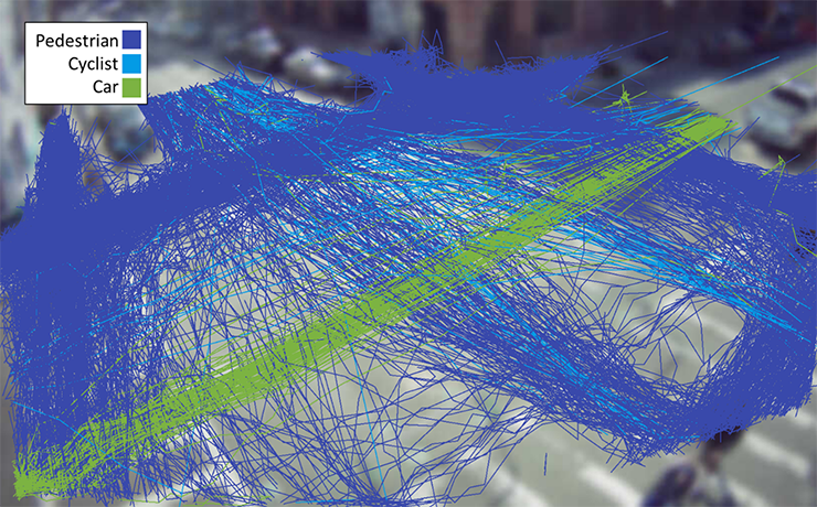
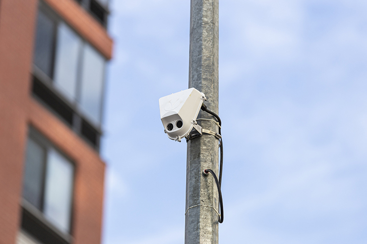
Authorized for installation by NYC DOT, street activity sensors are small devices mounted onto street light poles. The device views the street via a camera, then classifies and counts roadway users in real-time. Video frames from the sensors are deleted nearly instantaneously - and only anonymous features are stored. During the pilot, the devices will:
- Identify up to nine different modes of travel, including pedestrians, bicyclists and standing e-scooters
- Count modes of travel in real-time, and witness travel patterns that change with seasonality
- Represent paths of travel (by mode)
- Measure speed of travel
- Count turning movements
- Detect “near-miss” events between road users
If the street activity sensor pilot is successful, NYC DOT will scale up use of the sensors citywide - in the expectation that sensors will be a key component for the agency in building traffic models that can more accurately forecast the number of people walking and biking along New York City streets.
The Data
Data collected by these devices includes counts of different types of road users, paths of travel, and travel speeds. Counts include: cars, trucks, bicycles, scooters, buses, pedestrians, and more. The data does not include any other identifying information about the roadway’s users.
Viva will also provide street activity count data by analyzing video footage from temporarily installed cameras or existing live feeds. The City of New York owns the data collected by these devices and data sets will be available at the end of the pilot via NYC Open Data.
Locations
NYC DOT is installing a total of 12 street activity sensors in a variety of locations around the city. From roads primarily serving vehicles to pedestrian priority areas, the variety of areas will help determine how well the devices work in different types of urban environments. The pilot locations are:
Brooklyn
- Schermerhorn Street & Smith Street
- Flushing Avenue & Vanderbilt Avenue
- Berry Street & North 6th Street
- Hoyt Street & Warren Street
Bronx
- Willis Avenue & East 135th Street
Manhattan
- Central Park West Drive & Columbus Circle
- 1st Avenue & East 59th Street
- Brooklyn Bridge
- 6th Avenue & West 23rd Street
Queens
- 34th Avenue & 77th Street
- Broadway & Vietor Avenue
- 11th Street & 44th Drive
Protecting Privacy
The pilot prioritizes privacy, identifying data-collection methods that protect privacy by removing identifying information of roadway users and discarding video frames after counts are collected on the device.
The street activity sensor pilot is a partnership among NYC DOT, New York City’s Office of Technology and Innovation (OTI), and the City University of New York (CUNY), and was funded primarily by a grant from the New York State Empire State Development Corporation (ESDC), with underlying support from Federal RAISE and Safe Streets For All grants.
For more information about Viva, please visit: https://vivacitylabs.com/north-america/