DOT is creating a capital project to redesign and reconstruct Fordham Plaza in the Bronx. Fordham Plaza is a 1.75-acre open-air multi-modal transit nexus at the heart of the Bronx. It is the terminal destination for three local bus routes and it hosts key stops for four additional local bus routes, three regional bus lines, and New York City's first bus rapid transit line, the Bx12 Select Bus Service. The public plaza is the vital connection point between these surface transit routes, which provide service to approximately 43,000 daily riders, and the Fordham Metro-North regional rail station which, with 11,000 daily riders, is the third busiest station system-wide for Metro-North Railroad after Grand Central Terminal and Stamford Station. Fordham Plaza anchors the Fordham Road retail corridor, one of New York's busiest, with pedestrian volumes exceeding 80,000 in a 12-hour period \u2013 comparable to 34th Street/Herald Square or Seventh Avenue/Penn Station in Manhattan. The project will enhance the public space for commuters, residents, shoppers and local office workers. The new plaza will tie together the surrounding neighborhoods and visually link the area's cultural institutions to a central gathering space. The plaza redesign will include a cafe and multiple food kiosks, along with a variety of seating types and gathering spaces. DOT will reconstruct the street-level plaza, reconfigure the circulation of buses through the plaza and create a block-long bus-only transit mall on Third Avenue to maximize transit efficiency, and make geometric and operational modifications to the surrounding streets to significantly alleviate traffic congestion, increase pedestrian safety and improve the overall coherence of the project area. New York City Economic Development Corporation has completed a detailed conceptual design study with extensive community input.
Download a slideshow on EDC’s conceptual plan (Presented in July 2009)Read DOT’s finding that an environmental review is not required on this project(CEQR Type II Determination)Download the NEPA assessment checklistDownload the federal wage rate certification
Southern Boulevard and Crames Square Intersection Improvements
Complete Streets
The complex, five-legged intersection of Hunts Point Avenue, East 163rd Street and Southern Boulevard in the Bronx suffers from safety problems for pedestrians, traffic congestion and overall confusion. Improvements will begin during the Summer of 2010. Based upon collaboration with community members, DOT will shorten crosswalks and add landscaped refuge islands in order to reduce congestion and increase safety for all users. These changes can be evaluated to determine what permanent measures might be constructed. DOT held a public meeting in November, 2009 with members of the Longwood community in South Bronx to hear their concerns and ideas for improving the area around Crames Square for pedestrians. DOT used this feedback to define the proposed changes.
Download an updated slideshow about the Southern Boulevard and Crames Square project (Presented to Bronx Community Board 2 in October 2010)Download a slideshow about the Southern Boulevard and Crames Square project (Presented to Bronx Community Board 2 in November 2009)
Allerton Avenue from Olinville Avenue to East Gun Hill Road in the Bronx will be modified in June and July to calm traffic, enhance the streetscape, provide safer pedestrian crossings and provide a bicycle lane with connections to the Bronx River Greenway. Portions of Allerton Avenue fall within the Pelham Gardens Safe Streets for Seniors area and a high incidence of speeding was observed during this study. The roadway will be narrowed to one moving lane in each direction with a wide flush center median. Pedestrian refuge islands and left turn bays will be installed at key intersections, and a new bike lane in both directions will help connect cyclists to the Greenway. Modifications at the intersection of Bronx Park East and Allerton Avenue will be made to reduce traffic delay and improve flow.
Download a slideshow about the Allerton Avenue project (pdf) (Presented to Brooklyn Community Board 11 in June 2009)
This project calmed traffic in Red Hook through the installation of a green median where Columbia Street widens. The median provides a refuge for crossing pedestrians and helps to connect the neighborhood while adding a green amenity. Striped bicycle lanes provide a connection to the existing Brooklyn Waterfront Greenway. In 2010, DOT extended the bike lanes and traffic calming to south IKEA and the waterfront park.
Download a slideshow on the Columbia Street extension (Presented to Brooklyn Community Board 6 in June 2010)Download a slideshow on the original Columbia Street project (Presented to Brooklyn Community Board 6 in June 2009)
Empire Boulevard Streetscape Improvements
Complete Streets
Empire Boulevard from Bedford Avenue to Utica Avenue in Brooklyn will be modified in July, 2009, to calm traffic, enhance the streetscape, provide safer pedestrian crossings and provide a bicycle lane with connections to Prospect Park. The intersection of Empire Boulevard and Troy Avenue ranked 2nd in 2007 as a citywide high pedestrian crash location. In addition, a high incidence of speeding was observed along this corridor. The roadway will be narrowed to one moving lane in each direction with a wide center median. Pedestrian refuge islands and left turn bays will be installed at key intersections, and a new bike lane in both directions will help connect cyclists to Prospect Park.
Download a slideshow about the Empire Boulevard project (pdf) (Presented to Brooklyn Community Board 9 in June 2009)
Flatbush Avenue at Church Avenue
Pedestrian Mobility and Safety
Flatbush Avenue at Church Avenue will be improved for pedestrian safety and to reduce traffic congestion. The changes clarify the path for through-traffic smoothly around double-parked vehicles mid-block and left-turning vehicles at the intersection. Pedestrian exposure to vehicles in the crosswalks will be reduced.
Download a slideshow about the Flatbush Avenue at Church Avenue project (pdf) (Presented in May 2009)
Kent Avenue in Brooklyn is being re-designed. The goals of the project are to provide Curbside Access for parking and loading; reduce speeding and improve safety for all street users; enhance the bike lanes and provide a connection to the future Brooklyn Waterfront Greenway and popular waterfront destinations; and to manage truck traffic. The project will be implemented in two phases starting in August 2009 from Clymer Street to Broadway, and then in September from Broadway to North 14th Street. Kent Avenue will be converted to one-way northbound for vehicular traffic. A "floating" parking lane will be added on the west side of the street and loading zones along east curb. A two-way bike path will be added to the west side of the curb.
Download a slideshow about the Kent Avenue project (pdf) (Presented in August 2009)Information for trucks and delivery vehiclesCommunity Information FlyerUpdate for the Williamsburg / Greenpoint community (Presented to Brooklyn Community Board 1 in September 2009)
Metropolitan and Bushwick Avenues Intersection Traffic Calming
Complete Streets
The traffic calming of Metropolitan and Bushwick Avenue in the Cooper Park area of Brooklyn will increase pedestrian safety and access. The ideas were first proposed by neighborhood residents through their local Community Board. Landscaped pedestrian refuge islands at both Humboldt and Bushwick Avenues along Metropolitan will reduce conflicts while improving the streetscape for all road users. The sidewalk expansion on Orient Avenue at Metropolitan will provide a shorter crossing distance with a new crosswalk. It will also feature a landscaped drainage swale built by the Department of Parks & Recreation. For more details see the presentation to Brooklyn Community Board 1.
Download a slideshow about the Metropolitan and Bushwick Avenues project (pdf) (Presented to Brooklyn CB 1 Transportation Committee in June 2009)
DOT plans to close the two least used entrances and exits to Prospect Park at 3rd and 16th Streets. This change will reduce conflict between recreational users of Prospect Park (pedestrians and bicyclists) and motor vehicles. Park Drive will remain open to relieve rush hour traffic in peak directions between Grand Army Plaza and Park Circle. These changes are planned for spring 2009.
Download a slideshow about the Prospect Park project (pdf) (Presented to Brooklyn Community Board's 6 & 7 in April 2009)
Prospect Park West Bicycle Path and Traffic Calming
Prospect Park West runs along the western edge of Prospect Park in Brooklyn. It currently is the site of chronic speeding which sometimes leads to injury inducing crashes. The street is in a high bicycle use area, but does not have a bicycle facility, which can cause conflicts between cyclists, pedestrians and vehicles. This project will improve conditions for all users by installing a parking protected two-way bicycle path, removing one through travel lane and installing flush pedestrian refuge islands. This will enhance safety by creating shorter pedestrian crossings and reducing vehicle speeds. It will improve connectivity, mobility and safety by providing connections to existing bicycle lanes in Park Slope.
Download a slideshow about the Prospect Park West project April 2010(pdf) (Presented to Brooklyn Community Board 6 in April 2010)Download a slideshow about the Prospect Park West project April 2009 (pdf) (Presented to Brooklyn Community Board 6 in April 2009)Learn about the results of the Prospect Park West project
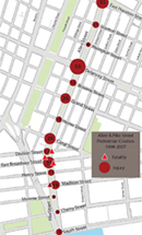
In 2009, DOT improved pedestrian safety on Allen and Pike Streets from East Houston Street to the water’s edge at South Street by creating a pilot expansion and enhancement of the malls. In addition to widened malls, the plan included a new separated left turn lanes, new crossings between the malls, protected bicycle lanes located adjacent the current malls and new public spaces where the center malls will connect through six intersections.
Download slides showing the results of the Allen-Pike Streets project (Presented to Manhattan Community Board 3 in June 2010)Download a slideshow about the Allen - Pike Streets project (pdf) (Presented to Manhattan Community Board 3 in April 2009)
Park Avenue Tunnel
Complete Streets
The intersection of Park Avenue and East 33rd Street in Manhattan had consistently been ranked highest in the number of pedestrian crashes in the City, holding this unenviable number one position from 1996 through 1998, and again in 2001 and 2003. This ranking is directly attributed to the unusual configuration of the intersection, which is located at the mouth of the Park Avenue Tunnel, which runs under Park Avenue between East 33rd and East 40th Streets. The tunnel had allowed for two-way motorized traffic, with one moving lane in each direction. However, visibility was severity limited at the southbound exit of the tunnel. And conditions as southbound Park Avenue surface traffic and southbound tunnel traffic exiting at East 33rd Street merged were sub-standard. Pedestrians crossing on the north leg of the intersection were at the most risk due to the limited visibility. For these reasons DOT had implemented a series of projects to improve overall safety, especially for pedestrians. But the location was still identified as a high crash location. In 2008, DOT decided to convert the Park Avenue tunnel to one-way northbound operation. The at-grade surface roadway of Park Avenue continues to operate southbound. Wider northbound tunnel and viaduct lanes were created to improve motorist safety and the pedestrian safety was enhanced by shortening crossing distance with the installation of pedestrian refuge islands and a neckdown.
Download a slideshow about the Park Avenue Tunnel project (pdf) (Presented in May 2009)
Twelfth Avenue at West 135th Street
Pedestrian Mobility and Safety
DOT is creating a green median on a wide portion of Twelfth Avenue at West 135th Street. The median allows for two-way traffic on a previously one-way street, improving vehicular access to a row of recently developed restaurants/night clubs. The landscaped median also increases safety and aesthetics for pedestrians accessing Riverside Park.
Download a slideshow about the Twelfth Avenue at West 135th Street project (pdf) (Presented in April 2009)
Queens
Jackson Avenue Streetscape Improvements
Pedestrian Mobility and Safety
In Spring 2009, DOT will improve pedestrian safety and enhance the streetscape of Jackson Avenue on the Queens side of the Pulaski Bridge. The project is being undertaken in response to community concerns with the intersection. Pedestrian refuge islands and the removal of the right-turn conflict with the east crosswalk will be included in the intersection redesign. A new south crosswalk will be installed at the foot of the bridge to benefit transit riders transferring from bus to subway as well as residents of this burgeoning neighborhood.
Download a slideshow about the Jackson Avenue project (pdf) (Presented in April 2009)