This project improves bicycle and pedestrian connections to Concrete Plant Park and Starlight Park, two new waterfront parks along the Bronx River Greenway. Working with the Department of Parks & Recreation and the Bronx River Alliance, DOT will enhance safety, access, and connectivity on Westchester Avenue, Edgewater Road between Starlight and Concrete Plant Parks, and Bruckner Boulevard. The Westchester Avenue improvements include a new crossing, safety improvements at Whitlock Avenue and at Bronx River Avenue, and a bicycle connection to existing lanes on Bryant Avenue, Longfellow Avenue, and East 167th Street. An on-street greenway connection between the parks will be created on Edgewater Road. On Bruckner Boulevard the planned improvements include a new crossing at Whitlock Avenue, a two-way protected bicycle path on Bruckner Boulevard, and a connection to the southern entrance of Concrete Plant Park.
Download the CB 2 slideshow about the Bronx River Greenway project (pdf) (Presented to Bronx Community Board 2 in January 2013)Download the CB 3 slideshow about the Bronx River Greenway project (pdf) (Presented to Bronx Community Board 9 in January 2013)
Bronxwood Avenue Traffic Calming
Complete StreetsMajor Transportation Projects
To improve safety along Bronxwood Avenue, DOT proposes removing one travel lane in each direction from 233rd Street to Boston Road to reduce speeding, installing left turn bays to organize traffic and keep through traffic moving, and installing a parking stripe to narrow moving lanes.
Download a slideshow about the Bronxwood Avenue project (pdf) (Presented to Bronx Community Board 2 in February 2013)
DOT is in the process of developing designs for a traffic calming treatment that will include a bicycle facility on Bartow Avenue and Co-op City Boulevard. This project will address the high number of people who have been severely injured in vehicle crashes on Bartow Avenue and the high frequency of speeding on Co-op City Boulevard. The lanes would be located on each side of Bartow Avenue and Co-op City Boulevard improving bicycle mobility within the neighborhood and enhancing access to the extension of the Hutchinson River Parkway Greenway which is under construction. Traffic calming benefits from this project will decrease vehicle speeds to safer level, reduce crashes and increase safety for all roadway users.
Download a slideshow about the Co-op City project (pdf) (Presented to Bronx Community Board 10 in April 2013)
DOT proposes improvements to pedestrian and bicycle safety on and around East 138th Street. The design includes dedicated bicycle lanes and painted curb extensions on East 138th Street and shared lane connections to the future Randall’s Island Connector bridge (via Walnut Avenue and East 132nd Street) and to the existing Prospect Avenue/Southern Boulevard bicycle routes (via Jackson Avenue and East 145th Street). In addition to organizing and calming traffic this project will address a gap in the bicycle network by providing a crosstown bicycle route for the south Bronx.
Download a slideshow about the East 138th Street project (pdf) (Presented to Bronx Community Board 1 in June 2013)
In response to requests from the local community board and neighborhood groups, DOT proposes improved bicycle connections to the Bronx River Greenway. This proposed bicycle route runs on East 222nd Street, linking the Greenway to Co-op City. The project will provide also create simpler, safer left turns, reduce speeding, and improve safety for all road users.
Download a slideshow about the East 222nd Street project (pdf) (Presented to Bronx Community Board 12 in February 2013)
East Tremont Pedestrian Safety Improvements
Pedestrian Mobility and Safety
This high crash corridor is unsafe and challenging for pedestrians to cross due to its width and high percentage of speeding vehicles. In response to community requests these new improvements include clearly defining and narrowing moving lanes, constructing neckdowns and safety islands, adding crosswalks, reconfiguring the signals for through and left turning traffic and adding landscaping.
Download a slideshow about the East Tremont project (pdf) (Presented to Bronx Community Board 10 in November 2013)
Grand Concourse Reconstruction
Complete Streets
This project will make permanent the interim reconfiguration on the Grand Concourse service roads between East 166th and East 171st Streets in the Bronx. The project will enhance safety and quality of life for users through the reduction of traffic speeds, widening and greening of the medians, installation of bike lanes and other traffic calming elements. It will also bring both the service roads and mainline up to a state of good repair through reconstruction and resurfacing.
Download a slideshow about the Grand Concourse project (pdf) (Presented in September 2013)
This project will permanently improve what had been a complex intersection of five busy streets, providing 15,000 square feet of vibrant pedestrian plaza space, safer and shorter pedestrian crossings, improved bus movement and easier transit transfers and bike lanes. It will also allow for a memorial to the late Roberto Clemente. The new car-free area will provide greatly needed pedestrian space in a busy shopping district and will enhance commuters’ transfers between two subway lines and five bus lines.
Williamsbridge Oval Park Safety Improvements
Complete Streets
In response to community requests, DOT is proposing pedestrian safety improvements around Williamsbridge Oval Park in the Bronx. Improvements will include painted sidewalks, new crosswalks, and improved signage which will greatly enhance the community’s access to the park.
Download a slideshow about the Williamsbridge Oval Park project (pdf) (Presented to Bronx Community Board 7 in April 2013)
Brooklyn
4th Avenue Corridor Improvements
Complete StreetsMajor Transportation Projects
Safety on Fourth Avenue in Brooklyn has long been a concern of DOT and the people who live and work along the corridor. DOT ranks Fourth Avenue as one of the highest-crash corridors in Brooklyn. In partnership with the Borough President’s Office, DOT has begun holding community workshops for sections of the corridor to develop design ideas for improving safety and traffic operations along Fourth Avenue. The first stage of street improvements is focused on Fourth Avenue between 15th and 65th Streets, a 2.5-mile stretch of Sunset Park that contains the highest incidence and severity of total traffic crashes and pedestrian injuries over the past five years. The Bay Ridge and Park Slope sections of the Avenue will follow.
Brooklyn and Manhattan Bridges: Downtown Brooklyn bicycle access improvements
Downtown Brooklyn has a robust bicycle network leading to the Brooklyn and Manhattan Bridges but important gaps remain even as cycling traffic over the bridges has increased dramatically. There is no designated route to Jay Street for cyclists exiting the Brooklyn Bridge and no designated route for cyclists to enter the Manhattan Bridge via Jay Street. Sands Street, which has also become a very popular cycling route, does not have a direct connection to the Brooklyn Bridge. This project will provide bicycle facilities on Tillary, Jay, Sands and Prospect Streets to enhance safety and convenience of cyclists using these heavily-used bridges.
Download a slideshow about the Brooklyn and Manhattan Bridges project (pdf) (Presented to Brooklyn CB 2 Transportation Committee in April 2013)
DUMBO / Vinegar Hill Street and Plaza Reconstruction
DOT is working with DDC, the DUMBO Improvement District, and the communities of DUMBO and Vinegar Hill to develop a design for a $20 million capital project to reconstruct cobble roadways and subsurface utilities on multiple blocks of DUMBO and Vinegar Hill and build out Pearl Plaza, a successful public space that DOT and DUMBO Improvement District implemented in 2007 using temporary materials. The streets in the project area consist of granite cobbles, generally in poor condition, with some sections of asphalt. These conditions impede bicycles, are difficult for pedestrians and do not meet Americans with Disability Act (ADA) guidelines. At the same time, community members feel strongly about preserving the character of the neighborhood to the greatest extent possible. DOT is committed to a design that restores all streets with granite cobble in a way that makes these streets available for all users, including cyclists. For the Pearl Plaza, the goal is to create a design responsive to community desires, that incorporates seating and landscape elements in a manner that is consistent with the context, and that provides maximum flexibility for programming. The plaza design will connect Pearl Plaza to an adjacent public space under the Manhattan Bridge Arch. This design project includes extensive community outreach, with three public workshops held as of March, 2013. Following a vigorous discussion about the cobble roadway design at a workshop in January, 2013, the designers incorporated neighborhood feedback and presented revised concepts at a workshop on March 20th. The project team then built granite cobble mock-ups which were viewed by approximately 50-60 members of the public. Based on public input, a presentation was made to the Community Board 2 executive board, which endorsed the project on July 22, 2013. The project design will be submitted and presented to the Landmarks Preservation Commission in September 2013.
Download a slideshow about the DUMBO / Vinegar Hill Street and Plaza project (pdf) (Presented to Community Board 2 in July 2013)Download the DUMBO / Vinegar Hill Street workshop presentation materials (pdf) (Presented in March 2013)
In response to community concerns about speeding, this project narrows Kent Avenue between Williamsburg Street West and Clymer Street and calms through traffic in both directions. Parking will be moved from the west curb to the east side of the center median to improve the street alignment with Kent Avenue south of the Brooklyn Queens Expressway and north of Clymer. On the west side of the street, the northbound bike lane will be moved from the sidewalk onto the roadway, easing the transition along the Brooklyn Waterfront Greenway for both pedestrians and bicycles.
Download a slideshow about the Kent Avenue project (pdf) (Presented to Brooklyn Community Board's 1 & 2 in December 2013)
Flatbush Avenue is a busy retail and transportation corridor surrounded by thriving neighborhoods with multiple subway stations and bus stops to serve these land uses, resulting in significant pedestrian volumes. Flatbush Avenue accommodates high volumes of local and through vehicles, however, the impacts of these vehicles on the pedestrian experience can be negative. This project, requested by the North Flatbush Avenue BID, will enhance pedestrian safety and the public realm, integrating all modes of transportation into the streetscape. Pedestrian space will be upgraded and in some cases expanded, including sidewalks and several triangles that are formed when Flatbush Avenue intersects with the numbered avenues.
Download a slideshow about the North Flatbush project (pdf) (Presented to Brooklyn Community Board 6 in September 2013)
Ralph Avenue & Ditmas Avenue Intersection Safety Improvements
Complete Streets
In response to community requests for vehicular and pedestrian safety improvements at the intersection of Ralph Avenue, Ditmas Avenue, East 83rd Street, Canarsie Lane and Clarendon Road, the DOT developed a plan to better organize and simplify the intersection, eliminate two dangerous left turns, provide two new crosswalks, one left turn signal and continuous sidewalk on the east curb of Ralph Avenue.
Download a slideshow about the Ralph / Ditmas Avenues project (pdf) (Presented to Brooklyn Community Board 17 in October 2013)
This project completes the east-west bicycle connection between the neighborhoods of Park Slope, Cobble Hill, and Gowanus, and to the growing Brooklyn Waterfront Greenway. Currently, the only westbound bicycle access across the Gowanus Canal is on 3rd Street—the Union and Carroll Street Bridges offer only eastbound access. In this project, DOT proposes a westbound (contraflow) bicycle lane on the Union Street Bridge, which will continue the Degraw Street lane to Nevins Street, over the canal, and connect to a new westbound lane to the waterfront along Sackett Street. Secondarily, the existing Union Street bicycle lane on will be extended to Van Brunt Street, creating a complete eastbound route from the waterfront to Prospect Park.
Download a slideshow about the Union and Sackett Street project (pdf) (Presented to Brooklyn Community Board 6 in March 2013)
DOT proposes upgrading the existing curbside buffered bike lane on Second Avenue between 14th and 23rd Streets to a parking protected bike path similar to the design located uptown and downtown of the project area. The proposed buffered lane adds parking back to the east side of the street to make the bike path parking-protected. The project will also provide simpler, safer left turns, shorten pedestrian crossing distances, and will improve the safety for all road users.
Download a slideshow about the 2nd Avenue project (pdf) (Presented to Manhattan Community Board 6 in October 2013)
Astor Place and Cooper Square serve as the gateway to the East Village and have a high level of pedestrian traffic due to the presence of a number of important institutions and transportation connections. This project will improve pedestrian mobility and community quality of life. The project brings a number of improvements to the street network and creates large areas of pedestrian space. Traffic will be realigned along Fourth Avenue creating additional open space adjacent to Peter Cooper Park, the pedestrian island housing the northbound 6 train will roughly double in size, and Astor Place between Lafayette Street and Fourth Avenue will be pedestrianized. In an effort to increase safety and shorten crossing distances. Medians will be constructed in the center of Third Avenue between 4th and 9th Streets.
Broadway and Dyckman Street - Riverside Drive Safety and Mobility Improvements
Complete Streets
DOT is proposing several left turn restrictions at this complex intersection to improve pedestrian safety. As a result of the turn restrictions, there will be two conflict-free crossings for pedestrians and overall, traffic will flow better.
Download a slideshow about the Broadway and Dyckman Street project (pdf) (Presented to Manhattan Community Board 12 in November 2013)
Broadway and Nagle Avenue Pedestrian Safety Improvements
DOT proposes concrete sidewalk extensions at the intersection of Broadway with Nagle and Hillside Avenues. This improvement will help to normalize this complex intersection, making crossing distances significantly shorter and easier to navigate for pedestrians. By closing existing slip turn lanes and creating a four corner intersection with right angle turns, movements will be clarified and made safer for all users. These improvements will take place through the capital process, in collaboration with the Department of Design and Construction.
Download a slideshow about the Broadway and Nagle Avenue project (pdf) (Presented to Manhattan Community Board 12 in November 2013)
DOT is working with Community Board 12 in Manhattan to make Inwood and Washington Heights safer for cyclists by expanding the bike network in the community. This ongoing conversation began in 2011 with a request from the community board for additional bicycle routes. DOT has evaluated priority routes, and will continue to develop design proposals, which will be presented to the Community Board in Fall 2013. Implementation is expected in phases, potentially starting in 2014.
Download a slideshow about the Inwood and Washington Heights project (pdf) (Presented to Manhattan CB 12 Transportation Committee in May 2013)
Work is underway on the Manhattan Bridge to replace all 628 bridge suspenders, rewrap main cables, replace and update lighting, and install access platforms for the bridge towers. During the construction, detours will sometimes be required for pedestrians and bicyclists. The project is scheduled to continue until Summer 2013. This work is part of a complete overhaul of the bridge, which began in 1982
Learn more about the Manhattan Bridge
Marcus Garvey Park Safety Improvements
Major Transportation ProjectsPedestrian Mobility and Safety
At the request of the Mount Morris Park Community Improvement Association, DOT has developed this proposal to improve the safety along the streets surrounding Harlem’s historic Marcus Garvey Park following a series of crashes in the area. DOT worked with the community to develop a plan that shortens pedestrian crosswalks, reduces speeding and crashes, and creates additional pedestrian space adjacent to the park.
Download a slideshow about the Marcus Garvey Park project (pdf) (Presented to Manhattan Community Board's 10 & 11 in January 2013)
To address high crash rates near PS 347, located at Second Avenue and East 23rd Street in Manhattan, DOT proposes curb extensions and neckdowns.
Download a slideshow about the PS 347 project (pdf) (Presented to Manhattan Community Board 6 in April 2013)
DOT proposes creating a missing and vital link in the Manhattan Waterfront Greenway by connecting the bike paths on East River Esplanade to the north and Peter Minuit Plaza to the south. The design will improve bicycle and pedestrian circulation and safety in front of the Battery Maritime Building on South Street by creating painted curb extensions; cyclists and pedestrians will share the space. In addition, queuing space will be created on the southbound direction side of South Street for vehicles servicing Governors Island.
Download a slideshow about the South Street - Battery Maritime Building project (pdf) (Presented to Manhattan Community Board 1 in October 2013)
University Place Pedestrian and Bicycle Enhancements
DOT proposes pedestrian, bicycling and parking enhancements to University Place to improve the one-way northbound corridor from Washington Square Place to Union Square. Pedestrian improvements include installing curb extensions at 5 corners along the corridor which have unusually narrow sections of sidewalk. The curb extensions can be designed with bicycle parking, plantings, seating or just room to walk or wait before crossing. A bicycle lane is proposed to be added to the west side of the street, set 10’ off the curb, beside the parking lane. Parking enhancements would include adding daytime paid parking regulations for shopping and dining and daytime paid commercial regulations for deliveries and loading.
Download a slideshow about the University Place project (pdf) (Presented to Manhattan CB 2 Transportation Committee in June 2013)
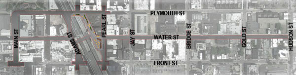
Water Street Corridor Enhancements
Pedestrian Mobility and Safety
Water Street, in Manhattan’s Financial District, serves as a key corridor for commerce, transportation, and increasingly residential development. With this project, DOT seeks to enhance the streetscape and improve the pedestrian environment while reorganizing traffic flows to improve safety. Crosswalks will be shortened, new pedestrian space will be created, curb usage will be assessed to maximize efficiency, and connections to the waterfront will be enhanced.
Download a slideshow about the Water Street project (pdf)
(Presented in March 2013)Download a briefing given to local property-owners (pdf) (Presented in March 2013)
DOT proposes a new crosstown bicycle route connecting Union Square and Hudson River Park, two of the most popular bicycling destinations in the City. The new route will be a mix of bicycle lanes and shared lanes on West 15th and 16th Streets between Union Square West and Hudson River Park. These bicycle markings will help organize the street, support the launch of Citi Bike and provide bicycle connections to existing bike lanes on Fifth and Sixth Avenues and bicycle protected paths on Eighth and Ninth Avenues. No travel lanes or parking spaces will be removed as part of this project.
Download a slideshow about the West 15th and 16th Street project (pdf) (Presented to Manhattan CB 4 Transportation Committee in March 2013)
West 177th St & Cabrini Blvd – George Washington Bridge Access
This project implements several key connections between two popular destinations for cyclists in Upper Manhattan, the George Washington Bridge and the Hudson River Greenway. DOT proposes installing fencing and bike stamps along the south side of 178th Street between Cabrini and the entrance to the path. The project also includes a two-way path from the bridge to the existing bike lanes along Fort Washington Avenue, traveling along Cabrini Boulevard between 178th and 177th and along 177th between Cabrini Boulevard and Fort Washington Avenue, a westbound path connecting Cabrini Boulevard to Haven Avenue, a new crosswalk on 177th across Cabrini, and extensive new wayfinding signage that will guide users along the new route.
Download a slideshow about the West 177th St & Cabrini Blvd project (pdf) (Presented to Manhattan Community Board 12 in April 2013)
West Broadway and Church Street Bicycle Facilities
DOT proposes a new bicycle route connecting Greenwich Village to Lower Manhattan. The route will consist of a mix of bicycle lanes and shared lanes on Church Street, Sixth Avenue, West Broadway, LaGuardia Place, Washington Square South, Washington Square East, Washington Square North, Broome Street and Varick Street. The routes will help organize the street, support short local trips by bike. No parking spaces will be removed as part of this project.
Download a slideshow about the West Broadway and Church Stree project (pdf) (Presented to Manhattan Community Board's 1 & 2 in September 2013)
"In 2012, DOT installed bicycle routes on four pairs of crosstown streets in Midtown Manhattan. The new lanes were added between First Avenue and Eighth Avenue on 39th/40th, 48th/51st and 54th/55th Street, and between Grand Central Terminal and Eighth Avenue on 43rd/44th Streets. This year, DOT proposed extending those routes east to the Hudson River, connecting the existing bicycle facilities to the Ninth Avenue Protected Bike Path and the Hudson River Greenway."
"Due to an ongoing DDC water main construction project on several blocks of West 48th and 51st Streets, Manhattan Community Board 4 voted not to support the extension on those streets until construction is complete. In 2017, DOT will revisit the proposal for extending the 48th Street and 51st Street bicycle routes."
Download a slideshow about the West Midtown project (pdf) (Presented to CB 4 Transportation Committee in February 2013)
In the Yorkville senior safety area, DOT proposes 3 neckdowns located on Third and York Avenues, a pedestrian safety island on East 86th Street and First Avenue, four loading zones, and a turn ban. The neckdowns and safety island shorten crossing distances for pedestrians and slow turns. The loading zones reduce vehicles swerving around loading trucks in moving lanes and increase visibility between pedestrians and drivers. The westbound left turn ban, from East 86th Street to Lexington Avenue, outside one of Manhattan’s busiest subway stations, would eliminate conflict between turning vehicles and pedestrians and better organize and improve traffic flow on East 86th Street.
Download a Slideshow about the Yorkville project (pdf) (Presented to Manhattan Community Board 8 in November 2013)
Queens
34th & 114th St (Citi Field) Bicycle and Pedestrian Access Improvements
DOT proposes improvements to access, circulation and safety for pedestrians and cyclists crossing 114th Street and the Grand Central Parkway on-ramp to connect to the multi-use path that leads to Citi Field. The design includes an expansion of the concrete median on 34th Avenue at 114th Street to organize the traffic and shorten the pedestrian and bicycle crossing distance; a relocation of the multi-use path to the signalized intersection to improve the safety of the crossing; and new intersection markings and signs for the Grand Central Parkway on-ramp crossing.
Download a slideshow about the 34th & 114th St project (pdf) (Presented to Queens Community Board 3 in June 2013)
The neighborhood of Auburndale, Queens applied for a Neighborhood Slow Zone in February, 2012. The application was accepted due to the proposed zone’s high frequency of crashes and injuries, strong natural boundaries and an appropriate local street network. The proposed treatments will lower the speed limit to 20 mph within the zone, improving safety for all roadway users, reducing traffic noise and cut-through traffic, and enhancing the social quality of the streets.
Download a slideshow about the Auburndale project (pdf) (Presented to Queens Community Board 11 in February 2013)
Due to regular and sometimes severe flooding, West 11th, 12th, and 13th Roads from Cross Bay Boulevard in Broad Channel, Queens, will be reconstructed at a higher elevation. In addition, new bulkheads will be constructed at the bay end of each street. These streets were selected due to their low grades and their susceptibility to flooding during high tides. This project will decrease the amount of time that the streets are flooded, decrease the frequency and severity of the flooding, and enable the water on the streets to drain back into the bay through the use of one way valves.
Download a slideshow about the Broad Channel project (pdf) (Presented in May 2013)
Brooklyn-Queens Expressway and 37th Avenue Pedestrian Safety Improvements
DOT plans a new northbound/southbound bicycle route on Crotona Avenue and Southern Boulevard between Crotona Park and Mosholu Parkway. The new route will be a mix of shared lanes on Crotona Avenue, bicycle lanes on Southern Boulevard, and off-street path markings on a path connecting Southern Boulevard to the Mosholu Parkway Greenway. These bicycle markings will organize the street, and no travel lanes, bus loading zones, or parking spaces will be removed as part of this project. The new route will provide a needed connection for cyclists travelling from the East Tremont and Belmont neighborhoods to Crotona Park and the cross-Bronx Mosholu Parkway Greenway.
Download a slideshow about the Crotona Avenue - Southern Boulevard project (pdf) (Presented to Queens Community Board 6 in February 2013)
P.S. 89 (the Elmhurst School) applied for a Neighborhood Slow Zone in February of 2012. The application was accepted due to a high crash rating, a large amount of schools and daycare centers, good natural boundaries and a strong residential character. The proposed treatments will lower the speed limit to 20 mph within the zone, improving safety for all roadway users, reducing traffic noise and cut-through traffic, and enhancing the social quality of the streets.
Download a slideshow about the Elmhurst project (pdf) (Presented to Queens Community Board 4 in January 2013)
Hillside Avenue and Homelawn Street Pedestrian Improvements
Complete Streets
DOT is proposing pedestrian safety improvements for the busy intersection of Hillside Avenue and Homelawn Street in Queens, which ranks in the top 1% of intersections in the borough for crashes. The plan provides safer, shorter crossings as well as new sidewalk space and landscaped safety islands to enhance the pedestrian network and clarify traffic movements.
Download a slideshow about the Hillside Avenue and Homelawn Street project (pdf) (Presented to Queens Community Board 8 in October 2013)
Metropolitan and 71st Avenues Intersection Improvements
Complete Streets
The community requested a safety study of this intersection in Forest Hills, Queens. The intersection was listed as a High Pedestrian Crash Location in 2011, and was the site of a traffic fatality that year. In response, DOT developed a plan that will organize traffic flow, reduce speeding, calm traffic and improve safety for all road users. The plan calls for left turn bays at the approach for simpler, safer left turns and school crosswalks for pedestrian visibility. To accommodate this new design, the removal of 14 parking spots and relocation of a Q54 bus stop are necessary. The remaining meters between 70th and 72nd Avenues will be changed to 2-hour parking to offset the loss.
Download a slideshow about the Metropolitan and 71st Avenues project (pdf) (Presented to Queens Community Board 6 in September 2013)
To address high crash rates near PS 169, located at 18th Avenue and 212th Street in Queens, DOT proposes refuge island, curb extensions, and neckdowns.
Download a slideshow about the PS 169 project (pdf) (Presented to Queens Community Board 7 in June 2013)
Thomson and Skillman Avenues Pedestrian & Traffic Safety Improvements
Complete Streets
To improve pedestrian and traffic safety and improve the pedestrian environment, DOT proposed banning the left turn from eastbound Thomson Avenue to northbound Skillman Avenue, closing of the slipramp at the intersection and the installation of planters and granite blocks at the closed slip ramp location.
Download a slideshow about the Thomson and Skillman Avenues project (pdf) (Presented to Queens CB 2 Transportation Committee in May 2013)
Vernon Boulevard – Queens East River Greenway Enhancement
As part of the Queens East River North Shore Greenway, this project connects several waterfront destinations along two miles of waterfront. The project proposes a two-way separated path on the west side of the street from 45th Road to 30th Road. It will connect recently constructed paths in Rainey and Queensbridge Parks, Hallet’s Cove, Socrates Sculpture Park, the new path between Queens Plaza and the Ed Koch Queensboro Park, and the commercial heart of Long Island City. The project provides an addition 35 parking spaces by routing the path through the park and replacing buffered bike lanes with shared lanes (separated paths are within the park).
Download a CB 2 slideshow about the Vernon Boulevard – Queens East River project (pdf) (Presented to Queens Community Board 2 in June 2013)Download a CB 1 slideshow about the Vernon Boulevard – Queens East River project (pdf) (Presented to Queens Community Board 1 in May 2013)
Staten Island
Hyatt Street Pedestrian Improvements
Complete Streets
Hyatt Street connects downtown St. George with the ferry and bus terminal. It is a vibrant pedestrian street, but is also in the top ten corridors for crashes in Staten Island. This proposal from DOT will add crosswalks and landscaped pedestrian space to the two blocks between St. Marks Place and Bay Street while rationalizing the street for all users.
Download a slideshow about the Hyatt Street project (pdf) (Presented to Staten Island Community Board 1 in October 2013)
The neighborhood of Rosebank, Staten Island applied for a Neighborhood Slow Zone in January, 2012. The application was accepted due to the proposed zone’s high frequency of crashes and injuries, strong natural boundaries and an appropriate local street network. The proposed treatments will lower the speed limit to 20 mph within the zone, improving safety for all roadway users, reducing traffic noise and cut-through traffic, and enhancing the social quality of the streets.
Download a slideshow about the Rosebank project (pdf) (Presented to Staten Island Community Board 1 in February 2013)