DOT narrowed service roads with raised planted medians and built Lou Gehrig Plaza in what had been a parking lot. DOT shrank the intersection of East 161st and Grand Concourse with shortened crosswalks and eliminated the merge between the Service Road and Main Line. Next, DOT will build permanent raised planted malls replacing the temporary planters between East 166th and 171st Streets.
Download the Grand Concourse Street Redesign project (pdf) (December 2008)
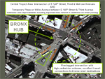
This DOT project will redefine the Bronx Hub with pedestrian safety improvements and a new public plaza. The project will provide a popular transit transfer point and pedestrian shopping destination with additional sidewalk and public space and new bicycle facilities connecting the Hub with other important destinations in the Bronx, Manhattan and beyond. The intersection redesign of E.149th Street and Third & Melrose Avenues will benefit pedestrian, bicycle, transit and traffic operations and provides HUB visitors and transit passengers with an attractive public space in which to experience all the area has to offer.
Download The Hub project (pdf) (Presented in August 2008)
Brooklyn
Broadway - Williamsburg Green Refuge Islands & Bike Lanes
The transformation of Williamsburg’s Broadway into a complete street that better serves drivers, cyclists and pedestrians is an example of the comprehensive planning utilizing innovative design elements that is being undertaken by DOT. Broadway was a wide street with little to vehicles and ensure they would yield to pedestrians. Cyclists had no accommodation. The redesigned Broadway organizes and calms traffic by dedicating space for pedestrians, cyclists and cars making left turns. The enhanced streetscape features pedestrian refuge islands that the Department of Parks and Recreation will plant in the fall of 2008.
Download the Broadway - Williamsburg project (pdf) (Presented to Brooklyn CB 1 in May 2008)
On June 7, 2008, DOT implemented a six month trial of new traffic patterns at the intersection of Adams and Tillary Streets in downtown Brooklyn. The goal was to improve safety for pedestrians, cyclists and motorists. Changes include modified signal timing, turn prohibitions, and reallocation of travel lanes. This resulted in more crossing time for pedestrians and cyclists crossing the intersection and/or accessing the Brooklyn Bridge and less potential conflicts with vehicles, and addressed local congestion by providing additional time for key vehicle movements, such as southbound left turns coming from the Brooklyn Bridge. Over the past 6 months, DOT staff worked with an ad hoc community stakeholder committee to gather feedback and monitor the results of these changes. Based on generally positive feedback and data indicating that the changes improved congestion at the intersection, DOT is proposing to make the changes permanent.
View the Final Plan of the Brooklyn Bridge Access project (pdf)Download the data and findings for the Brooklyn Bridge Access project (pdf) (Presented in December 2008)Download the Brooklyn Bridge Access project (pdf) (Presented in May 2008)
After reports of speeding on Clarendon Road, DOT studied the corridor and designed a solution to calm traffic and improve safety. With relatively low traffic volumes, the corridor will benefit from narrowed and defined lanes, with the addition of a painted center median when space allows, as well as bicycle lanes, which will provide a key east-west connection to the existing bicycle network.
Download the Clarendon Road project (pdf) (Presented to Brooklyn Community Board's 14 & 17 in May 2008)
DeKalb Avenue Traffic Calming and Bicycle Lane Project
Like many North Brooklyn neighborhoods, Fort Greene, Clinton Hill and Bedford-Stuyvesant are growing cycling communities. DeKalb Avenue is an important and heavily used multi-modal commuter corridor spanning all three neighborhoods. Many commuters travel on DeKalb Avenue to work, shop or connect with transit in Downtown Brooklyn on the heavily-used B38 bus line, by car or by bike, but there is no dedicated space for cyclists. This project aims to improve safety and comfort for cyclists and calm traffic on DeKalb Avenue, while preserving the multimodal capacity of the avenue. Implementation of the project is scheduled for June 2008.
Download the DeKalb Avenue project (pdf) (Presented to Brooklyn Community Board's 2 & 3 in March 2008)
This and plan was written to meet the multi-modal transportation needs of Downtown Brooklyn for the next 20 years. The blueprint integrates planning for pedestrians, transit users, cyclists, motorists and goods movement. The project considers the implications of growth; developing goals, policies, strategies and initiatives that are focused on maintaining and enhancing access, mobility and quality of life as development occurs.
Download a summary of the Downtown Brooklyn Blueprint (January 2008)Download details on the implementation of the Downtown Brooklyn Blueprint (Presented in January 2008)
Fulton Mall Streetscape Project - Albee Sq and DeKalb Avenue
As part of its Fulton Mall Streetscape Project, the New York City Economic Development Corporation, in coordination with DOT, will close to traffic DeKalb Avenue between Bond Street and Fulton Street and incorporate this reclaimed area into a landscaped pedestrian plaza. This closure has been approved by DOT. By law, all street closures lasting longer than 180 days are subject to a Community Reassessment, Impact, and Amelioration (CRIA) Statement or Environmental Assessment (EA), and a public forum prior to the statement’s issuance.
Download the Fulton Mall Streetscape project (pdf) (Presented in November 2008)
Hanson Place and Third Avenue Safety Improvements
Complete Streets
DOT will implement several safety improvements near Brooklyn’s LIRR Atlantic Terminal and the BAM cultural district. Pedestrians now encounter conflicts with vehicles accessing Hanson Place/Ashland Place from both Fourth Avenue and Flatbush Avenue. DOT will create a raised sidewalk between Flatbush Avenue and the intersection of Hanson Place/Ashland Place, which will protect pedestrians accessing Atlantic Terminal, One Hanson Place, and other destinations in this growing part of Downtown Brooklyn. Hanson Place between Ashland Place will be converted to two-way travel for local vehicular circulation. 3rd Avenue between Atlantic Avenue and Flatbush Avenue will be converted from two-way to one-way travel in order to improve safety and operations at the intersections of Third Avenue/Atlantic Avenue and Third Avenue/Flatbush Avenue.
Download the Hanson Place and Third Avenue project (pdf) (Presented to Brooklyn CB 2 Transportation Committee in October 2008)
In 2008, DOT put this four lane street into a "road diet." The redesigned street, running between Plaza Street East and Dean Street, has two vehicle lanes with bike lanes, a median and green refuge islands and the same carrying capacity. In response to a Community Board 2 request to study feasibility of enhanced bicycle facility connections, in 2010 DOT extended the successful bicycle facility design on Vanderbilt Avenue from Dean Street to Flushing Avenue. The improvements will increase safety for all road users by channelizing traffic and organizing street configuration, particularly at the intersection of Atlantic Avenue. Dedicated bicycle lanes will be provided from Dean Street to Gates Avenue and the facility will continue to the Brooklyn Navy Yard with a shared route design, providing connections to the well-used existing bicycle facilities in the neighborhood.
Download a slideshow of the Vanderbilt Avenue Bicycle Lanes extension (Presented to Brooklyn Community Board 2 in May 2010)Download images of the first Vanderbilt Avenue project (June 2008)Download a slideshow about the Vanderbilt Avenue project (Presented to Brooklyn Community Board 8 in April 2008)
To complement the protected bicycle path on Ninth Avenue just one avenue over, the existing buffered bicycle lane on Eighth Avenue will be upgraded to a separated bicycle path as well to create a safe and appealing bicycle route. Like the existing Ninth Avenue complete street redesign, Eighth Avenue will be transformed with planted pedestrian islands that will reduce crossing distance by 20-45 feet, as well as dedicated turning signals to separate bicycle and pedestrian conflicts.
Download a slideshow about the 8th Avenue project (pdf) (Presented to Manhattan CB 2 Transportation Committee in March 2008)
Chatham Square/Park Row Improvement Program
Following the terrorist attacks of September 11, 2001, the New York City Police Department (NYPD) implemented a security plan to protect its headquarters (1 Police Plaza), and other City, State and Federal facilities located in the Civic Center in Lower Manhattan. These facilities were and continue to be considered potential terrorist targets by the NYPD. The security plan established checkpoints and installed provisional booths and vehicle interdiction devices, closing several streets to general traffic. Because this plan required restrictions on portions of Park Row, a north-south connection between Chinatown and the Civic Center was lost to thru traffic and vehicular access for residents of Chatham Towers and Chatham Green became constrained. The NYPD prepared a detailed Environmental Impact Statement (EIS) that identifies significant impacts including: traffic, noise, air, and visual resources and urban design. The environmental review process, which concluded in 2007, recommended implementation of two major mitigation measures which this project will reconfigure Chatham Square and create a pedestrian promenade on Park Row.
Highlights of the landscape designs (pending Art Commission review) (January 2009)Landscape designs (pending Art Commission review) (January 2009)Download a slideshow about the Chatham Square / Park Row project (pdf) (November 2008)Chatham Square / Park Row Improvement Program technical designs (November 2008)
Chinatown Senior Pedestrian Focus Area Final Report
Safe Streets for Seniors is a major pedestrian safety initiative for older New Yorkers. DOT examined accident histories across the city and identified 25 city neighborhoods that had a high number of pedestrian crashes or injuries. DOT engineers evaluated pedestrian conditions in these neighborhoods from a senior’s perspective and made engineering changes, such as extending pedestrian crossing times at crosswalks, shortening crossing distances, altering curbs and sidewalks, restricting vehicle turns and narrowing roadways. The following report details the outcome of the study in the Chinatown Senior Pedestrian Focus Area in Manhattan.
Download the Chinatown Senior Pedestrian Focus Area Final Report (pdf) (November 2010)
Clinton Street: Williamsburg Bridge Bicycle Access Project
The Williamsburg Bridge is the most heavily traveled bridge for cyclists in New York City with approximately 2,600 cyclists crossing the bridge on a typical day. This project will create just under a mile of new bicycle lanes and routes on Clinton Street, providing safe and convenient access to and from the Williamsburg Bridge. In addition to linking the Lower East Side and East Village to the bridge, the project will make connections to the recently installed Grand Street bicycle lane to the south and a bicycle route on East Houston Street to the north.
Download the Williamsburg Bridge Bicycle Access project (pdf) (Presented to Manhattan Community Board 3 in March 2008)
Grand Street is an important cross-town bicycle route that provides convenient access to both the Williamsburg and Manhattan Bridges. In 2006 an on-street bicycle lane was installed on the route. On the two-way stretch east of Chrystie Street the facility functions well and has been a success. The functionality of the one-way portion west of Chrystie Street conversely, has been hampered by vehicles illegally parking and driving in the bicycle lane. This redesign of the one-way portion of Grand Street is intended to improve the operation of Grand Street for cyclists, pedestrians and motorists. The design will move the bicycle lane adjacent to the southern curb and reposition the south side parking 8 feet off the curb creating a parking protected bicycle path. To mitigate the conflict of vehicles turning across the bicycle path, a pilot treatment of mixing zones for cyclists and turning vehicles will be tested with this project.
Download the Grand Street Parking Protected Bicycle Path project (pdf) (Presented to Manhattan Community Board's 2 & 3 in July 2008)
Greenwich and Washington Streets Contextual Redesign
Complete Streets
In response to evolving land uses, community requests for traffic calming and regular traffic patterns after the long period of instability from the reconstruction of Route 9A, DOT developed a comprehensive contextual redesign for Greenwich and Washington Streets. The resulting improvements include new bicycle lanes, the removal of a motor vehicle lane on Washington Street, marked traffic calming, new traffic signals, improved visibility of crosswalks, signal timing plans that prioritize pedestrians and quality of life, and new curbside regulations that reflect the growth in the residential population of the corridor. The project was presented to Manhattan’s Community Board 3 in January and implementation of most project elements will be completed in April.
Download the Greenwich and Washington Streets project (pdf) (Presented to Manhattan Community Board 2 in December 2007)
As part of PlaNYC the DOT is working to improve pedestrian and motor vehicle movement around subway entrances and bus stops to make accessing mass transit easier and more convenient.
Download a slideshow about the Lower East Side project (pdf) (Presented in September 2008)
Safe Streets for Seniors is a major pedestrian safety initiative for older New Yorkers. DOT examined accident histories across the city and identified 25 city neighborhoods that had a high number of pedestrian crashes or injuries. DOT engineers evaluated pedestrian conditions in these neighborhoods from a senior’s perspective and made engineering changes, such as extending pedestrian crossing times at crosswalks, shortening crossing distances, altering curbs and sidewalks, restricting vehicle turns and narrowing roadways. The following report details the outcome of the study in the Stuyvesant Town Senior Pedestrian Focus Area in Manhattan.
Download the Stuyvesant Town Senior Pedestrian Focus Area Final Report (pdf) (November 2010)
Warren Street provides a direct eastbound route from Hudson River Greenway to the Brooklyn Bridge promenade via the north path of City Hall Park. This connection will provide a safe alternative to Chambers Street, one block to the north, and serve as the eastbound pair to existing westbound bicycle lane on Reade Street. Making this safe and direct connection between two heavily used segments of the bicycle network is essential to making bicycle transportation a viable and attractive means of moving about the City.
Download a slideshow about the Warren Street and City Hall Park project (pdf) (Presented to Manhattan Community Board 1 in June 2008)
West 106th Street is a key route in the NYC Bicycle Master Plan, providing convenient crosstown access across the Upper West Side to popular recreational amenities and other bicycle routes. The installation of bicycle lanes on West 106th Street presents an opportunity for a complete street redesign to make the street safer and more comfortable not only for cyclists, but for all street users.
Download a slideshow about the West 106th Street project (pdf) (Presented to Manhattan Community Board 7 in April 2008)
Queens
Jackson Heights Senior Pedestrian Focus Area Final Report
Safe Streets for Seniors is a major pedestrian safety initiative for older New Yorkers. DOT examined accident histories across the city and identified 25 city neighborhoods that had a high number of pedestrian crashes or injuries. DOT engineers evaluated pedestrian conditions in these neighborhoods from a senior’s perspective and made engineering changes, such as extending pedestrian crossing times at crosswalks, shortening crossing distances, altering curbs and sidewalks, restricting vehicle turns and narrowing roadways. The following report details the outcome of the study in the Jackson Heights Senior Pedestrian Focus Area in Queens.
Download the Jackson Heights Senior Pedestrian Focus Area Final Report (pdf) (November 2010)
St. Stanislaus Kostka School Safety Project, Maspeth and Grand Avenue