Movable Bridges over Newtown Creek
- Pulaski Bridge
- Greenpoint Avenue Bridge
- Grand Street Bridge
- Metropolitan Avenue Bridge
- Borden Avenue Bridge
- Hunters Point Avenue Bridge
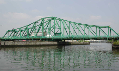
Pulaski Bridge over Newtown Creek

The Pulaski Bridge, which carries six lanes of traffic and a pedestrian sidewalk over Newton Creek and the Long Island Expressway, is orientated north-south and connects Greenpoint in Brooklyn to Long Island City in Queens. McGuinness Boulevard approaches the bridge from the south and Eleventh Street from the north. The Pulaski Bridge is a 54m double leaf, trunnion type bascule bridge. It has two 10.5m roadways divided by a concrete median barrier. It also carries a 2.7m pedestrian sidewalk. The bridge provides a channel with a horizontal clearance of 45.7m and a vertical clearance of 11.9m in the closed position at MHW and 13m MLW.
The Pulaski Bridge was opened to traffic on September 10, 1954. The bridge was reconstructed in 1994 at a cost of approximately $40 million. The project included new approach roadways, new superstructure and approach spans, and upgrade of the bridge's mechanical/electrical systems.
Pulaski Avenue Bridge Facts
- Bridge ID Number: 2-24063-9
- Type: Bascule
- Location: Borden Avenue & Ash Street
- Waterway: Newtown Creek
- Miles from Mouth: 0.6
- Channels: 1
- Used by: Highway
- Total Cost: $11,228,141.00
- Date Opened: Sep. 10, 1954
Greenpoint Avenue Bridge over Newtown Creek

Greenpoint Avenue is a four-lane local street in Queens and Brooklyn, running northeast from the East River in Greenpoint, Brooklyn to Roosevelt Avenue in Sunnyside, Queens. The Greenpoint Avenue Bridge, also known as the J. J. Byrne Memorial Bridge, is located approximately 2.2 km from the mouth of Newtown Creek. The bridge is situated between Kingsland Avenue in Greenpoint, Brooklyn and Review Avenue in the Blissville section of Queens. The Greenpoint Avenue Bridge is a double-leaf trunnion bascule, with 21.3 m wide leaves. This bridge is a steel girder structure with a filled grid deck. The bridge provides a channel with a horizontal clearance of 45.4 m and in the closed position a vertical clearance of 7.9 m at MHW and 9.4 m at MLW. The bridge structure carries a four-lane two-way vehicular roadway with a 1.2m striped median and sidewalks on either side. The roadway width is 8.6m and the sidewalks are 4.0m and 3.7m for the north and south sidewalk respectively. The approach roadways are narrower than the bridge roadway. The west approach and east approach roadways are 17.1m (including 1.4m center median) and 11.9m respectively.
The first bridge on this site, a drawbridge known as the Blissville, was built in the 1850's. It was succeeded by three other bridges before a new one was completed in March 1900 at a cost of $58,519. That bridge received extensive repairs after a fire in 1919 damaged parts of the center pier fender, the southerly abutment, and the superstructure. Until that time, the bridge had also carried tracks of the Long Island Rail Road. The current bridge was built in 1987.
Greenpoint Avenue Bridge Facts
- Bridge ID Number: 2-24037-0
- Type: Bascule
- Location: between Kingsland & Review Avenues
- Waterway: Newtown Creek
- Miles from Mouth: 1.3
- Channels: 1
- Used by: Highway
- Total Cost: $1,923,968.23
- Date Opened: December 3, 1929
Grand Street Bridge over the East Branch of Newtown Creek
Grand Street Bridge Project
NYC DOT is progressing the Grand Street Bridge Project over the Newtown Creek. It will address the structural and geometric deficiencies of the bridge, improve the bridge's resiliency, and ensure continued operational reliability for multi-modal users- cars, buses, trucks, pedestrian, bicycles, and marine vessels.
Learn more about the Grand Street Bridge Project at
nyc.gov/GrandStreetBridge
Grand Street Bridge Overview
Grand Street is a two-lane local City street in Queens and Kings Counties. Grand Street runs northeast and extends from the Brooklyn Queens Expressway in Brooklyn to Queens Boulevard in Queens. The road is known as Grand Street west of the bridge and Grand Avenue east of the bridge. The bridge is located between Gardner Avenue in Brooklyn and 47th Street in Queens. The Grand Street Bridge is a 69.2m long swing type bridge with a steel truss superstructure. The general appearance of the bridge remains the same as when it was opened in 1903. The bridge provides a channel with a horizontal clearance of 17.7m and a vertical clearance, in the closed position, of 3.0m at MHW and 4.6m at MLW. The bridge structure carries a two-lane two-way vehicular roadway with sidewalks on either side. The roadway width on the bridge is 6.0m and the sidewalks are 1.8m wide. The height restriction is 4.1m. The approach roadways are wider than the bridge roadway. For example, the width of Grand Avenue at the east approach to the bridge (near 47th Street) is 15.11m.
The first bridge on this site, opened in 1875, quickly became dilapidated due to improper maintenance. Its replacement, opened in 1890, was declared by the War Department in 1898 to be "an obstruction to navigation." Following a thorough study, a plan was adopted in 1899 to improve the bridge and its approaches. The current bridge was opened on February 5, 1903 at a cost of $174,937.
Grand Street Bridge Facts
- Bridge ID Number: 2-24039-0
- Type: Swing
- Location: 47th Street & Gardner
- Waterway: Newtown Creek
- Miles from Mouth: 3.1
- Channels: 2
- Used by: Hwy
- Total Cost: $205,671.72
- Date Opened: Feb. 3, 1903
Metropolitan Avenue Bridge over English Kills

Metropolitan Avenue is a two-way local City street in Kings and Queens Counties. The number of lanes varies from two to four along the entire length of Metropolitan Avenue, which runs east-west and extends from River Street in the Southside section of Brooklyn to Jamaica Avenue in Queens. The bridge, the only one over English Kills, carries both Metropolitan Avenue and Grand Street. The bridge is situated between Vandervoort and Varick Avenues in the East Williamsburg section of Brooklyn. The Metropolitan Avenue Bridge is a double leaf bascule bridge with a span of 33.8 m. The general appearance of the bridge has been significantly changed since it was opened in 1931. The bridge provides a channel with a horizontal clearance of 26.2 m and a vertical clearance, in the closed position, of 3.0 m at MHW and 4.6 m at MLW. The bridge structure carries a four-lane two-way vehicular roadway with sidewalks on either side. The roadway width is 16.2 m and the sidewalks are 1.8 m. There are no height restrictions on the bridge.
After the City acquired Metropolitan Avenue from the Williamsburg and Jamaica Turnpike Road Company in 1872, the existing bridge was replaced by a swing bridge, which was also used by the Broadway Ferry and Metropolitan Avenue Railroad Company. Growth in the area made the bridge inadequate by the early 20th century. The current bridge was built in 1931. Modifications since then have included upgrading the mechanical and electrical systems and the replacement of deck, bridge rail, and fenders. The stringers were replaced and new stiffeners added in 1992.
Metropolitan Avenue Bridge Facts
- Bridge ID Number: 2-24029-0
- Type: Bascule
- Location: Varick & Vandervoort Streets
- Waterway: English Kill
- Miles from Mouth: 3.4
- Channels: 1
- Used by: Hwy
- Total Cost: $634,634.86
- Date Opened: Mar. 27, 1933
Borden Avenue Bridge over Dutch Kills

The Borden Avenue Bridge over Dutch Kills is located just south of the Long Island Expressway between 27th Street and Review Avenue in the Blissville neighborhood. The roadway width is 10.5m and the sidewalks are 2.0m wide. The west approach and east approach roadways, which are wider than the bridge roadway, are 15.3m and 13.0m respectively. The bridge provides a horizontal clearance of 14.9m and a vertical clearance in the closed position of 1.2m at mean high water and 2.7m at mean low water.
Borden Avenue Bridge is a retractile bridge, meaning that the bridge deck opens by sliding diagonally back to shore. It is one of four remaining bridges of its type in the nation. Another example is the Carroll Street Bridge over the Gowanus Canal in Brooklyn.
As part of the construction of Borden Avenue in 1868, a wooden bridge was built over Dutch Kills. This bridge was soon replaced with an iron swing bridge, which was removed in 1906. The current bridge opened on March 25, 1908 at a cost of $157,606. The deck's original design consisted of creosote-treated wood blocks, with two trolley tracks in the roadway. The characteristic features of the bridge include the stucco-clad operator's house and a rock-faced stone retaining wall. The gable-on-hip roof of the operator's house retains the original clay tile at the upper part. Although alterations have been made, the bridge is a rare survivor of its type and retains sufficient period integrity to convey its historic design significance.
Borden Ave Bridge Facts
- Bridge ID Number: 2-24041-0
- Type: Retractile
- Location: 27th Street & Review Avenues
- Waterway: Dutch Kills
- Miles from Mouth: 1.2
- Channels: 1
- Used by: Hwy
- Total Cost: $191,612.26
- Date Opened: May 5, 1908
Hunters Point Avenue Bridge over Dutch Kills
Hunters Point Avenue is a two-lane local City street in Queens. Hunters Point Avenue is oriented east-west and extends from 21st Street to the Long Island Expressway/Brooklyn Queens Expressway interchange in Queens. The avenue is parallel to and approximately one block south of the Long Island Expressway. The Hunters Point Bridge over Dutch Kills is situated between 27th Street and 30th Street in the Long Island City section of Queens, and is four blocks upstream of the Borden Avenue Bridge. It is a bascule bridge with a span of 21.8m. The general appearance of the bridge has been significantly changed since it was first opened in 1910. The bridge provides a channel with a horizontal clearance of 18.3m and a vertical clearance, in the closed position, of 2.4m at MHW and 4.0m at MLW. The bridge structure carries a two-lane, two-way vehicular roadway with sidewalks on either side. The roadway width is 11.0m, while the sidewalks are 1.8m wide. The width of the approach roadways vary from the width of the bridge roadway. The west approach and east approach roadways are 13.4m and 9.1m, respectively.
The first bridge at this site, a wooden structure, was replaced by an iron bridge in 1874. That bridge was permanently closed in 1907 due to movement of the west abutment, which prevented the draw from closing. It was replaced in 1910 by a double-leaf bascule bridge, designed by the Scherzer Rolling Lift Bridge Company. The bridge was rebuilt in the early 1980's as a single-leaf bascule, incorporating the foundations of the previous bridge.
Hunters Point Avenue Bridge Facts
- Bridge ID Number: 2-24045-0
- Borough: Queens
- Type: Bascule
- Telephone: 718-937-4255
- Location: 27th Street & 30th Street
- Waterway: Dutch Kill
- Miles from Mouth: 1.4
- Channels: 1
- Used by: Hwy
- Total Cost: $108,985.56
- Date Opened: Dec. 14, 1910