
 Lower Manhattan Coastal Resiliency311Search all NYC.gov websites

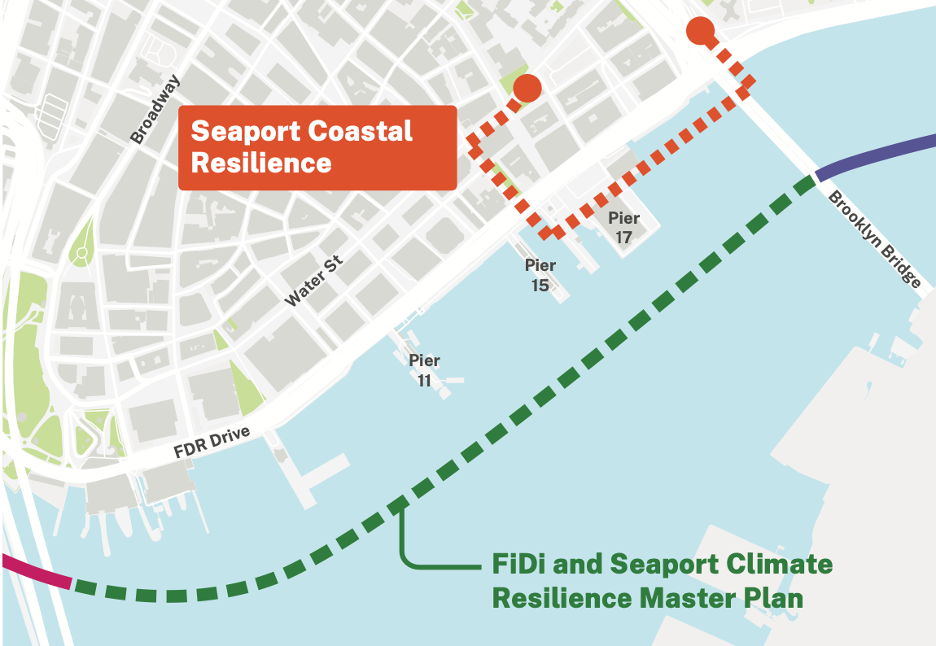
Seaport Coastal Resilience

Seaport Coastal Resilience (SPCR) aims to protect the Seaport neighborhood from current and future frequent tidal flooding. As one of the lowest-lying areas in the region, the Seaport neighborhood is particularly vulnerable to regular flooding events. Without intervention, sea level rise and tidal flooding events are projected to impact the Seaport neighborhood with increasing frequency, with regular monthly flooding to occur by the 2050s and daily flooding predicted by the 2080s.
The New York City Panel on Climate Change projects up to 6.3 feet of sea level rise by 2100. This poses a significant threat to residential buildings, businesses, public spaces, infrastructure, and historic character of the Seaport neighborhood.
To ensure the long-term resilience and viability of the neighborhood, Seaport Coastal Resilience (SPCR) plans to raise the elevation at the water’s edge to 11 feet above sea level. This will help the region withstand and recover from regular flooding events.
SPCR aims to reduce coastal flood risk while maximizing community benefits and improving the functionality, services, and accessibility of the waterfront. The project will include demolition and reconstruction of the New Market Pier (adjacent to Pier 17) at a level that is protected from sea level rise. The Pier will be accessible to the public after the project is completed. The future use of the Pier will be further studied and determined by the City outside of the SPCR process.
Design Goals
SPCR shall address the following design goals:
- To ensure protection from 2100 Sea Level Rise within the project area
- Drainage and green infrastructure elements, including new inlets, piping, manholes, and outfalls for directly managing runoff, including runoff from the drains of the FDR Drive viaduct
- Potential public realm enhancements which may include pedestrian and new community recreational access, available greenery access to the waterfront, enhanced and continuation of bike access, public access to hard and softscapes, and other green infrastructure elements, within the project area, including South Street, the local street network, the FDR Drive, and the bikeway
- Demolition and reconstruction of the New Market Pier to a higher, protected elevation that integrates with adjacent portions for flood control
- In-water ecological enhancements that can support a diversity of marine flora and fauna species
How to Get Involved
There will be numerous opportunities for the public to provide input throughout the design phase of the project and beyond. Community Open Houses and Workshops will be timed with key project milestones. Additional outreach will be conducted to provide a variety of ways for the public to participate. Public and community input will be carefully reviewed and considered during the project's development. Additionally, community members can stay engaged by attending Comunity Board 1 meetings and participating in public events during the environmental review process.
Click to receive general project updates on SPCR news directly in your email inbox.
Sea Level Rise versus Storm Surge and Rain Events
Long-term infrastructure developments are required to protect the Seaport neighborhood from sea level rise, which is projected to cause daily flooding in the neighborhood by 2080. Elevating the waterfront and constructing coastal defenses will provide the Seaport neighborhood with permanent, day-to-day protection from tidal flooding events.
In contrast, storm surge and extreme weather events cause a temporary increase in water levels well above normal tide levels. Protecting against these storm events requires the construction of significantly higher flood protection systems and drainage infrastructure that can manage and divert stormwater.
It is important to note that this area is already witnessing rising sea levels. The project plans for Seaport Coastal Resilience (SPCR) account for sea level rise projections up to the year 2100, demonstrating a conservative estimation, which is currently the best practice and the standard used by the City on other resilience projects.
SPCR and the FiDi and Seaport Climate Resilience Master Plan
SPCR is a separate project from the FiDi and Seaport Climate Resilience Master Plan, although both projects will provide flood protection for the neighborhood. SPCR has a narrow geographic focus on the Seaport neighborhood between John Street and the Brooklyn Bridge. In contrast, the FiDi and Seaport Climate Resilience Master Plan has a broad geographic focus along the waterfront, spanning almost a mile from The Battery to the Brooklyn Bridge. The FiDi and Seaport Climate Resilience Master Plan has a longer time horizon for completion and will protect the area from a 100-year storm surge through 2100, while SPCR will provide more immediate protection to the neighborhood's most vulnerable areas.
SPCR and other Lower Manhattan Coastal Resiliency (LMCR) Projects
SPCR plays a crucial role in the broader New York City-led efforts to fortify Lower Manhattan against the increasing threat of coastal flooding and sea level rise. As part of the comprehensive LMCR Project strategy, SPCR focuses on safeguarding the Seaport neighborhood, which is particularly vulnerable due to its low-lying location.
SPCR intersects with other key LMCR initiatives, such as the Brooklyn Bridge-Montgomery Coastal (BMCR) project, which will implement permanent flood walls and deployable flip-up barriers to protect the Two Bridges neighborhood from coastal storm surge. The northern section of SPCR will connect with completed BMCR infrastructure to ensure continuous flood protection along the waterfront.