


Testimony of Rohit T. Aggarwala Chief Climate Officer and Commissioner, NYC DEP before the NYC Council Committee on Environmental Protection, Resiliency, and Waterfronts and Committee on Parks and Recreation
October 11, 2023
Good afternoon, Chair Gennaro, Chair Krishnan, and members of the Committees on Environmental Protection, Resiliency, and Waterfronts and Parks and Recreation. I am Rohit T. Aggarwala, Chief Climate Officer of New York City. I oversee the Mayor’s Office of Climate and Environmental Justice (MOCEJ), and I am also the Commissioner of the New York City Department of Environmental Protection (DEP). I am joined today by Elijah Hutchinson, the new Executive Director of MOCEJ; and Marit Larson, Assistant Commissioner of Natural Resources and Planning, at the New York City Department of Parks and Recreation (Parks).
Thank you for the opportunity to speak today on New York City’s climate resiliency efforts. Climate change is here. We have all witnessed its impact, as recently as less than two weeks ago, when Tropical Storm Ophelia brought extreme rainfall on September 29. Since day one, the Adams administration has been focused on better preparing the city for the impacts of climate change, including creating my position as the city’s Chief Climate Officer. As the first person to serve in the role, I work closely with the Mayor’s Office of Climate and Environmental Justice, also created by Mayor Adams by combining several separate offices, bringing environmental justice to the forefront.
MOCEJ leads the city’s efforts to ensure New York City is reducing its emissions while also protecting New Yorkers from the intensifying impacts of climate change. With a focus on equity and public health, MOCEJ works to make buildings efficient and resilient; ensure infrastructure is climate-ready; transform streets and the public realm into living, open spaces; and make energy clean and resilient.
I am particularly excited about the addition of Executive Director Hutchinson to MOCEJ. He previously led coastal resilience and new greenway initiatives as Vice President for Waterfronts at the New York City Economic Development Corporation (NYCEDC). His work and ideas will be central to this city’s climate policy, including its resiliency policy going forward, and I am pleased to have him as my colleague.
Climate Hazards: Why Resiliency Is Important
Climate change presents a real threat to New York City and the 8.4 million New Yorkers who call it home. According to the New York City Panel on Climate Change, sea levels in New York City have already risen by a foot since 1900 and are expected to rise by up to 5.4 additional feet by the end of the century, contributing to chronic tidal flooding and heightened coastal storm surge. The city’s average annual precipitation is projected to increase up to 10 percent in the 2030s and as much as 30 percent by 2100.
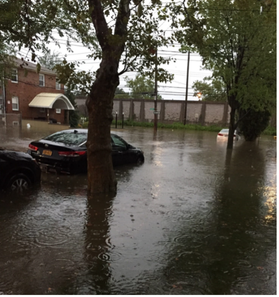
The events we experienced last month were the latest example of our new normal. It was frightening, but what’s even scarier is we know more of these events are coming. We have had three record-breaking rainfalls in the last two years. This September was the wettest month the city has experienced in 100 years.
Though we have been focused in recent weeks on extreme rainfall, I want to point out that extreme heat kills more people, in New York and nationally, than all other climate threats combined. Last summer, 370 New Yorkers died of heat-related illnesses and Black New Yorkers die of heat-related illness at twice the rate of white New Yorkers. Extreme heat is getting worse: New York City's annual average temperature is projected to increase up to almost five degrees Fahrenheit by the 2030s. There are projected to be up to six times as many days above 90 degrees per year by the 2080s from our current baseline.
Access to air conditioning, which saves lives, is generally high but as low as 76 percent in certain neighborhoods. The majority of people who die from heat exposure inside their homes die in apartments without a functioning air conditioner. Cooling is a life-saving feature that needs to be part of New York City's building regulations.
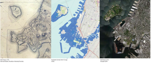
If we were in any doubt climate change is upon us, as of the last five years, New York City is now within the humid subtropical climate zone, which requires that summers average above 72 degrees and that winters average above 27 degrees. When we face flooding events like we experienced last month, we must remember we are a coastal city built on historic waterways. Most of the locations that experienced severe flooding on September 29 were in fact locations that were streams, creeks, tidal flats, or other waterways before they were filled in for development. As the historian Eric Sanderson and author of Mannahatta wrote, water has memory.
Flooding Types
Climate change brings more intense and more frequent flooding events because it adds extra moisture to the atmosphere, making storms more intense and harder to manage. There are several different types of flooding, with different causes and different management techniques.
Late last month, areas of the city were hit with extreme rainfall, or cloudbursts. It was the most intense rainfall since Hurricane Ida two years ago. During cloudburst events, a lot of rain falls in a short time, which can overwhelm stormwater management systems. Low-lying areas, areas with poor drainage, and areas with insufficient stormwater infrastructure, including inland neighborhoods, are particularly vulnerable to stormwater flooding.
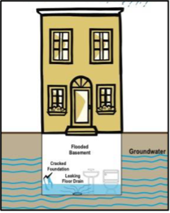
Both cloudburst events and slow, steady rain can lead to groundwater flooding. Groundwater flooding occurs when the ground becomes so oversaturated it can no longer hold the water. If water finds penetration points, such as cracks in foundation or a leaking flood drain, it starts to seep into basements.
Properties along the city’s 520-mile coastline are vulnerable to two additional types of flooding: coastal surges and chronic tidal floods. Coastal surges happen when a large amount of seawater rushes onto land, as the city experienced during Hurricane Sandy. The frequency and intensity of coastal surges are exacerbated by sea level rise. Since 1900, sea level in our city has risen 12 inches and is projected to continue to increase by as much as 6.25 feet by 2100.
Chronic tidal flooding, which is also called sunny day flooding because it can occur on sunny days, occurs when water from regular high tides breaches the land, even without storms. This impacts our low-lying coastal communities. Sections of the city’s coastline will be subject to daily tidal flooding by the 2050s. Some low-lying areas are already experiencing chronic tidal flooding.
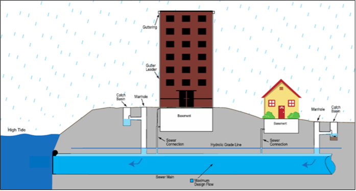
High tides can also exacerbate other types of flooding. Tides can even impact inland communities, if high tide water comes up the sewer system outfall and prevents stormwater from draining, leading to street flooding and oversaturating the ground, contributing to groundwater flooding. Some of the hardest hit areas on September 29 were contending with tidal flooding and extreme rainfall at the same time.
City’s Climate Work: Fighting Against and Adapting to Climate Change
Under Mayor Adams, MOCEJ and partner agencies have been advancing short-, medium- and long-term solutions to respond to these many threats. We call this a multi-layered, multi-hazard approach.
In the summer of last year, the mayor and I announced Rainfall Ready, which outlines steps the city and New Yorkers can take to combat extreme rainfall. It built on initiatives announced in The New Normal, which was put out within weeks of Hurricane Ida and outlined actions to protect New Yorkers from future intense precipitation events.
Recently, the Mayor released PlaNYC: Getting Sustainability Done, the administration’s first holistic climate plan. PlaNYC builds on lessons from Hurricanes Sandy and Ida, from the climate plans of previous administrations, and from goals outlined in The New Normal. Rather than just outlining a vision, this is an action plan, focused on real, impactful actions to make things happen, including leveraging unprecedented federal funding.
Just six months after its release, many of the plan’s 72 initiatives are underway, including our stormwater flooding adaptation plan, housing mobility program, tree canopy expansion, implementation of congestion pricing, and, in collaboration with our partners at the United States Army Corps of Engineers (USACE), our world-class, neighborhood scale coastal protection projects.
We are not done. Just last month, we released Getting 97 Done, a mobilization strategy for buildings to comply with Local Law 97, which the Council passed in 2019. We also released PowerUp NYC, the city’s first long-term energy plan.
Combatting Flooding
The city is combating flooding with a variety of measures, but it goes without saying that changing infrastructure takes a serious investment of time and money. Projects need engineers, project managers, and procurement staff, which limits the number of projects we can do at once. The bigger the project, the faster that work is done, but the more projects we tackle at once, the more it is going to cost. DEP’s flooding resiliency work is funded by water rate money. We must be cognizant that more investment more quickly could mean raising water rates. When making decisions about balancing needs, we have to factor in ratepayers’ needs.
More than 70 percent of New York City is covered by surfaces that aren’t absorbent, which means more than 70 percent of the city’s surface is not managing flood waters. Traditionally, the city has relied on storm sewer systems to remove flood water from our streets, but our sewer infrastructure was designed for a different weather world than the one we have now. Some parts of the city have sewers only designed to manage 1.5 inches of rain, or less, in an hour. Our current standard is 1.75 inches per hour.
When the intensity exceeds that rate, the stormwater sewers can’t keep up with the pace and streets can begin to flood. During Hurricane Ida, parts of the city received 3.75 inches in an hour—more than twice the maximum sewer capacity. During Tropical Storm Ophelia, some areas were hit with more than 2.5 inches in one hour. It becomes a problem when intense rain continues over time; this is why we saw flooding on September 29 but not the previous weekend, when there was a steady but slow rain over several days. We are currently re-evaluating our 1.75-inch standard, but it is not feasible to create a sewer system large enough to manage the most intense storms. Sewers are just one tool in the toolbox for managing water.
Sewer Improvements
DEP has recently completed a citywide all-pipes hydraulic model. Through this several year-effort, DEP has produced a first-of-its-kind and comprehensive digital representation of the city’s sewer system, which will be used to analyze the existing system performance and for drainage planning. DEP will continue to refine and build upon the model to maximize its utility. This will help support capital planning, prioritization, stormwater management, and flood mitigation. In addition, DEP will use the model to better integrate innovative solutions, such as the Bluebelt program, with traditional grey infrastructure to meet current and future drainage needs.
Long-Term Sewer Improvements
DEP has been working with the Department of Design and Construction (DDC) and other partner agencies to expand stormwater sewer systems, particularly in areas that were developed without them, like areas of Southeast Queens.
For several years, DEP and partner agencies have been working on a $2.6 Billion project to install storm sewers and other critical infrastructure throughout neighborhoods in Southeast Queens. Part of the funding the city dedicated to infrastructure after Hurricane Ida was allocated for ramping up sewer expansions specifically in this area.
DDC and DEP are engaged in a storm sewer project in Gowanus that will lead to cleaner water and reduce flooding. This ongoing work will reduce flooding in Gowanus and Park Slope, in particular prioritizing the area around the intersection of 4th Avenue and Carroll Street, which experiences flooding regularly even during storms that don’t rise to the intensity of one like Ophelia. With this work, we expect a 40 percent reduction in flooding during a typical storm by next year and a 100 percent reduction in 10 years.
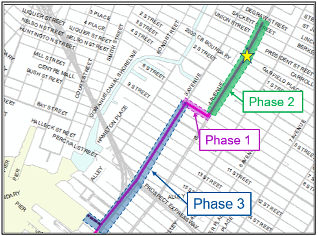
- Phase 1: 7th St. between 3rd and 4th Ave.
- Increase capacity by 78%
- 2024 → 40% flood reduction
- Phase 2: 4th Ave. between Degraw and 7th St.
- Increase capacity by 167%
- 2031→ 50% flood reduction
- Phase 3: 3rd Ave. between 7th and 22nd St.
- Increase capacity by 495%
- 2033→ 100% flood reduction
Additional major projects are underway in central Queens, Broad Chanel, South Beach, Staten Island, and in Southern Brooklyn. Where projects have been completed, neighborhoods have seen real, significant results. During the storm last month, our teams checked on several previous chronic flooding locations, documenting the impacts of the work.
Short-Term Sewer Work
Full sewer expansion takes time, so we are looking for shorter term solutions wherever possible, installing high-level storm sewers, which drain directly to the waterways without connecting to the larger sewer system.
We have seen successes with this type of infrastructure. For example, last week, the mayor joined fellow Commissioners, Executive Director Hutchinson, and me to tour the Jewel Street neighborhood in Brooklyn and Queens. This area is commonly nicknamed “the hole,” a reference to its basin shape. For decades, that basin has filled with flood waters any time there is rain, and sometimes when there is sun. In some instances, it has taken literally weeks for the flood waters to fully recede. DEP and our partners have focused efforts in this area, including installing new sewer infrastructure earlier this year. Thanks to that infrastructure work, the approximately seven inches of rain that fell on the neighborhood on September 29 eased within hours and completely dissipated in two days—a significant improvement over Hurricane Ida, when a similar volume of rainfall took weeks to fully clear. The work around “the hole” is not done, but at least we have been able to provide some relief to residents while bigger projects are still pending.
Part of maintaining an effective stormwater sewer system is ensuring water can actually get into the sewers, which means making sure all of the city’s approximately 150,000 catch basins are functioning properly. Last year, DEP implemented a data-driven inspection schedule that prioritizes catch basins and commercial and other heavily trafficked areas, where we have found that cleanings are needed more often. With this schedule, catch basins in the highest need areas are proactively inspected twice per year and basins in lower need areas are proactively inspected less frequently. This allows our teams to use limited resources as effectively and efficiently as possible.
Green Infrastructure
Green infrastructure refers to infrastructure assets that, in contrast to “gray infrastructure” like sewers, absorb water and allow it to naturally infiltrate into the ground. New York City has been investing heavily in a variety of green infrastructure asset types, including:
- Rain gardens, infiltration basins, stormwater green streets
- Green roofs, blue roofs
- Permeable pavement
- Subsurface detention systems
- Rain barrels and cisterns
- Daylighting natural water bodies
Between 2012 and 2022, DEP and partners have “greened” about 2,300 acres of land around the five boroughs. About 90 percent of our green infrastructure has been installed in environmental justice neighborhoods.
Green infrastructure is particularly beneficial because it manages stormwater before the water gets to sewers, keeping volume out of the system. We estimate newly installed green infrastructure will capture more than 369 million gallons of stormwater annually. In addition, green infrastructure provides important “co-benefits” for communities, beyond managing stormwater. These additional benefits include increased urban greening, reduced urban heat island impact, more habitats for birds and pollinators around the city, and general beautification of city streets.
Bluebelts
The city remains committed to expanding its Bluebelt Program. Bluebelts increase the system’s capacity by utilizing existing streams, ponds, and wetlands, partnering these natural bodies with storm sewers to safely drain large volumes of stormwater. The water naturally filters before eventually flowing to the New York Harbor. There are 94 Bluebelts citywide. Staten Island’s 83 Bluebelts provide drainage for more than a third of the island. There are also 10 in Queens and one in the Bronx. Several additional Bluebelts are currently in the pipeline, and DEP engineers are determining what sites around the city are feasible for future Bluebelts.
A secondary benefit of Bluebelts is they attract birds and other wildlife, improving the city’s ecological health, increasing biodiversity, beautifying neighborhoods, and even contributing to increasing property values in their neighborhoods. We are always looking for opportunities for more community-driven infrastructure, like Bluebelts, that serves multiple purposes.
Cloudburst Systems
This past January, the administration announced four cloudburst hubs in Corona/Flushing Park, Kissena, Parkchester, and East New York. Cloudburst systems are designed specifically to manage cloudburst events of intense, overwhelming rainfall by incorporating multiple strategies.
These four locations were selected using a framework that examined historic and future stormwater flooding hotspots, existing city projects, environmental justice areas, and social factors that may increase vulnerability to stormwater flooding. Construction is expected to begin in 2025.
These four sites add to existing work in South Jamaica and St. Albans in Queens and East Harlem in Manhattan. An eighth cloudburst area has been chosen in Brownsville, Brooklyn. More than two dozen additional locations are being evaluated for future projects. DEP will continue to aggressively apply for federal funding to support this vital work and expand this critical program.
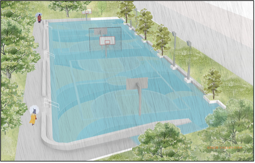
Like Bluebelts, cloudburst systems also provide benefits to communities beyond managing stormwater. The systems are built as community spaces to provide services during dry weather. For example, the cloudburst project designed for NYCHA’s South Jamaica Houses is a sunken basketball court that will absorb and divert stormwater during future storms. Most days, the basketball court will provide recreation for residents. During cloudburst events, the stormwater will intentionally be diverted to the court, which will hold the water safely until the rain is over, taking that rainwater off the street and out of the sewers.
These projects are funded with $390 Million in city capital.
Unified Stormwater Rule
The city cannot meet our stormwater management needs with work on public land alone. We need cooperation from private property. For many years, DEP has offered incentives and assistance for private spaces to install green infrastructure, including offering grant funding for green roofs.
In 2022, DEP rolled out the new Unified Stormwater Rule, which increases the amount of stormwater that new and redeveloped properties must manage on-site. When stormwater is managed on-site, it stays out of the stormwater system and does not contribute to backups or overflows.
Coastal Flood Protection
As mentioned earlier, flooding doesn’t just come from storms. It can also come from the coasts. The city has been focused on coastal resiliency since the devastation of Hurricane Sandy. We are currently advancing many projects to address coastal storm surge. East Side Coastal Resiliency (ESCR) is an integrated flood protection system comprised of a combination of floodwalls, land elevation, floodgates, and interior drainage infrastructure improvements. The project includes elevating East River Park approximately eight feet and installing flood protection in the new space beneath it. Spanning 2.4 miles along the east side of the Lower Manhattan waterfront, from Montgomery Street north to East 25th Street, it will provide protection against storm surge and sea-level rise for 110,000 vulnerable New Yorkers while delivering critical waterfront open space and access improvements.
The Brooklyn Bridge-Montgomery Coastal Resiliency project will provide critical flood protection in the Two Bridges neighborhood through a series of deployable flip-up gates and floodwalls, while also maintaining access and visibility to the waterfront, and protect 30,000 New Yorkers, forty percent of whom are public housing residents.
The Seaport Coastal Resiliency Project will protect the most low-lying and vulnerable part of the shoreline between Fulton Street and the Brooklyn Bridge, which includes almost 100 buildings and 1,000+ jobs, against sea level rise and storm surge, mostly through raising the bulkhead.
The Financial District and Seaport Climate Resilience Master Plan, released in December 2021, is a blueprint for comprehensive flood defense infrastructure for two low-lying neighborhoods, where nearly one million people work, live and commute, from coastal storms and sea level rise. Implementation of the full plan is estimated to cost $5 to $7 Billion.
The Battery Park Resilience project will rebuild and elevate the wharf promenade in The Battery, an important historic and revenue-generating asset for the city, staying true to the character and uses of the park, while protecting it from sea level rise in the year 2100. Construction began earlier this year.
The South Battery Park City Resiliency Project is a continuous flood barrier from the Museum of Jewish Heritage, through Wagner Park, across Pier A Plaza, and along the northern border of Historic Battery Park. The North and West Battery Park City Resiliency Project will span the North Esplanade, extending into Tribeca.
HATS
The city has been working closely with USACE, the state, and New Jersey on the New York-New Jersey Harbor and Tributaries Study (HATS), which will inform work to protect our region from storm surges. USACE released its Draft Report and Environmental Impact Study (EIS) last fall. Its preliminary recommendation for a $52 Billion plan proposes storm surge reduction measures for New York Harbor that include individual in-water and/or land-based flood reduction measures. The city has long advocated for many of these. During the comment period, the city submitted feedback to USACE, articulating the project outcomes for the study:
- The proposed projects must serve multiple purposes, address multiple risks, and integrate into the local urban context;
- Projects must be delivered as efficiently and flexibly as possible;
- A phased approach with ability to prioritize project implementation for the disadvantaged/socially vulnerable communities; and
- Engagement with the communities must be well-planned and well-resourced throughout the life of the study and its resulting projects.
USACE is currently reviewing all the public comments and determining what additional analysis, evaluation, and concept design may be needed to complete the study before they issue the final recommendation and report.
Bureau of Coastal Resilience
PlaNYC proposes the creation of a new Bureau of Coastal Resilience within DEP. DEP’s leadership role will allow for streamlined decision making and faster capital project implementation. Streamlining this work helps the city design, construct, and operate coastal protection projects, and helps New Yorkers by providing a central point of contact on flooding.
Though all agencies play a role in creating a more resilient coastline, there is a need for one agency to have final responsibility as this portfolio of work grows. Assigning leadership responsibility to one agency will unify long-term planning and funding; increase coordination and efficiency; and improve maintenance of flood resilience projects. This new structure will also provide a central point of contact and information for New Yorkers on coastal and rainwater flooding events across the city. DEP is uniquely situated to take on this leadership responsibility because it complements the existing mission for flood resilience planning and operations. DEP’s experience operating emergency and just-in-time systems and delivering complex construction projects will be critical for the coastal resiliency work we expect.
Preparing Residents
New York City is a collective community of interconnected systems and people. The work the city is doing must be supported by work on private properties. Further, because infrastructure work takes time, residents and business owners must have the tools to protect themselves and their property from climate threats like flooding. Some of the most important work we are doing is to provide those tools. Much of storm preparedness is about awareness, which is why we expanded FloodHelpNY.org, which MOCEJ runs in partnership with the Center for NYC Neighborhoods. FloodHelpNY.org is a user-friendly website and communications tool to promote a greater citywide awareness of flood risk, flood insurance, and flood resiliency retrofits. Flood insurance is the best financial resource available after a flood to address damages.
Rainfall Ready and DEP Tools
As I mentioned earlier, we released Rainfall Ready last year to help residents prepare for rain and flooding events. It includes commitments from the city, and advice for homeowners and other residents about what to do in preparation for, immediately before, during, and after storms. DEP issued a new map, available online, which identifies properties around the city we believe to be most susceptible to flooding.
DEP regularly partners with Council Members and other elected officials to hold distribution events and information sessions around the city, where we supply residents and business owners with rain barriers, inflatable water barriers, and even sump pumps. This summer, DEP worked with local elected officials and community boards to hold more than 100 rain barrel giveaways and provide nearly 15,000 rain barrels to residents. The information and tools from these events empower residents and business owners to protect their properties during floods.
FloodNet.NYC
FloodNet.NYC is a network of street flooding sensors designed to help the city better understand the frequency, severity, and impacts of flooding events. There are currently 74 sensors in place. The city funded the program with $7.2 Mllion, enabling us to increase the number of flood-prone areas and monitors to 500 FloodNet sensors by 2027 in high-priority neighborhoods vulnerable to high tides, storm surge, and precipitation events. FloodNet captures real-time flooding conditions in New York, allowing us to prioritize interventions and direct resources before and during flooding events.
Voluntary Mobility and Land Acquisition Program
We understand moving and the impacts of flood damages on homes and families is personal and often traumatic. As we develop a voluntary Housing Mobility and Land Acquisition Program, we are taking a human-centered approach and coordinating extensively among agencies.
The city will launch an entirely voluntary Housing Mobility & Land Acquisition Program, which means residents in highly vulnerable coastal and stormwater risk areas can let the city know whether they’re interested in participating in a future buyout and receiving housing, financial counseling services, estate planning, and relocation support. No residents will be forced to relinquish their property. Through our program, the city will work with flood vulnerable residents to ensure they understand their options, including opportunities to move. The city will convert acquired properties to resilient and sustainable uses that bring tangible benefits, helping to reduce the overall flood impacts to neighborhoods through an increase in green infrastructure and open space such as Bluebelts, parks, and wetlands.
More than Just Flooding
Heat
The impacts of climate change aren’t limited to floods. Extreme heat rarely makes the headlines like other extreme weather, in part because wealthiest New Yorkers can cool their homes to escape the worst consequences.
In PlaNYC, we announced several initiatives to help us combat extreme heat, such as achieving a 30 percent canopy cover in the city, planting more than 30,000 native trees and shrubs, and making open spaces more accessible and connected. Increasing biodiversity also provides community health and social benefits.
Climate Strong Communities
Through the Climate Strong Communities program, MOCEJ is developing equitable multi-hazard resiliency projects focused in areas of the city that still face disproportionate risks from climate change challenges. It is designed to invest in communities left unaddressed by Hurricane Sandy recovery funding. Community feedback and engagement are critical components. Communities were selected based on criteria that prioritized equity, climate risks, and project opportunities. We also select communities with high social vulnerability to climate hazards and face multiple climate hazards. Communities were selected based on the ability for the program to achieve risk reduction with city-led adaptation or sustainability projects led through CSC. Our Year One communities are East Harlem and Canarsie; Corona, Brownsville, Soundview, and Port Richmond.
Program engagement will value and learn from the lived experiences and expertise from residents to guide and inform work; lead a transparent process; implement and integrate resident expertise into project design and applications; ensure people feel empowered and comfortable coming to the table; and compensate residents for their time and sharing their expertise.
Buildings
Buildings are the single greatest contributor of greenhouse gas emissions in the city. The groundbreaking Climate Mobilization Act of 2019 requires most large buildings to meet new energy efficiency and greenhouse gas reduction milestones by 2024 and 2030 and is estimated to create up to 140,000 jobs.
But roughly 15,000 buildings will need $12-15 Billion to comply with 2030 emissions limits at current costs and with current technology, and only about a third would pay for itself through energy savings. Getting 97 Done is our strategy for compliance. We are working to ensure 97-covered buildings can receive the $625 Million we estimate they can access in federal tax refunds and subsidies from the Inflation Reduction Act. We are also calling on you to expand J-51 tax abatement approved by the New York State Legislature to help our low- and moderate-income buildings comply with the law. In addition, we are working with the City Council to hold workshops with buildings known to be at risk of noncompliance to match them with the free one-on-one technical assistance program NYC Accelerator and answer questions about LL97.
Clean Energy
A critical component of protecting us from climate threats is transitioning to clean and renewable energy sources. We have committed to 100 percent clean electricity by 2040 and have initiatives to launch a public solar program, maximize climate infrastructure on city-owned property, and build an EV charging network.
The state estimates we will need 6GW of battery storage by 2030, with 2GW located in NYC. We are committing to streamlining and accelerating storage projects in pursuit of these targets, and initiatives detailed in PowerUp NYC, our long-term energy plan, will help us achieve them. The city is also progressing on solar deployment and is nearly halfway to its target to deploy 1000 MW of solar citywide by 2030.
Looking Forward
Our multi-layered strategy, which includes sustainability as well as resiliency measures, means we are fighting many fires at once. What we call sustainability—work to reduce emissions—is part of a resilience strategy. We will continue our work to implement Local Law 97, support the MTA in the implementation of congestion pricing, promote a circular economy, convert gas to grid, keep New Yorkers safer from heat, and create green jobs. I want to personally thank the Council, and Chair Gennaro in particular, for the work you have all been doing to both lead and support the work of the past few administrations. I would like to point out some of the challenges facing any of us engaged in climate adaptation work.
Speed and Capacity
Major physical projects take a significant amount of time, typically one to three years for planning and design, one to two years for procurement, and from one to four years of construction. To reduce this time would require changes to several processes, such as environmental review, ULURP when acquisitions are required, and procurement rules.
DEP has invested significantly in improving our procurement, with great success. We have reduced a nearly a two-year procurement cycle to down to just one-year. Further, we have improved internal processes to increase our commitment rate. One of our big disappointments of FY22 was we achieved only a 69 percent commitment rate for the year. Through a significant whole-of-agency effort, we are proud to report that, for the first time in 10 years, DEP achieved our capital commitment target, reaching 103 percent of our $2.3 Billion goal. DEP committed $2.4 Billion dollars in new capital projects, a year-on-year increase of $800 Million of new projects breaking ground for construction or starting into design.
DEP has contributed to the Capital Process Reform Task Force convened by Mayor Adams and Comptroller Lander. Last year, the Task Force released a set of recommendations, including using price adjustment allowances to offset volatile commodity prices, expanding work allowances to reduce change order approvals, and amending procurement laws and regulations. Also, significantly, the Task Force has made recommendations for the city to adopt alternative project delivery mechanisms such as Progressive Design Build and has proposed the DDC become an Authority. We strongly support these recommendations, as these efforts will speed up capital projects, reduce costs, and increase the City’s capacity to address emerging needs. We look forward to continuing to work with the mayor, partner agencies, the comptroller, and the council to identify additional opportunities for improvement.
While there aren’t a lot of easy ways to speed up an individual project, we also face constraints in how many we can take on at once. This is basically a function of DEP’s planning and engineering capacity, and DDC’s engineering and contracting capacity. I would welcome any help the City Council can offer in figuring out how to increase DEP’s and DDC’s capacity to deliver projects, or how the city’s design, procurement, and construction timetables can be speeded up.
Trade-Offs in Resilience Work
Climate work is generational and because of that, there are trade-offs. We must balance water rate affordability with our resilience considerations. Stormwater projects are breathtakingly expensive. Starting last year, DEP has been working on a set of example projects to understand by extrapolation what it would take to create true stormwater resilience across the city. In 2021, my predecessor estimated it would require a cost of $100 Billion, which would require us to raise water rates by 500 percent. Depending on the level of stormwater resilience we want, we may have to brace for dramatic increases in water bills. This is not theoretical; as we begin work towards our FY2025 capital plan, it would be helpful to know what Council Members think about how much to invest, given all of our investments in stormwater resilience are passed along in the water bill.
We must also consider the importance of affordable housing to resilience work. Three key strategies for resilience—requiring air conditioners, protecting people who live in basement apartments, and a voluntary mobility program available to those who live in at-risk properties—are likely to directly reduce the city’s affordable housing supply. We cannot have both affordable housing and resilience unless we dramatically increase the creation of new housing across the city, and we need to recognize some homes are impossible to protect from flooding. MOCEJ has been collaborating closely with DCP on City of Yes: Zoning for Housing Opportunity, which was kicked off in September, on the issues of basement apartments and flood risk, and the considerations of climate hazards when siting and building new housing.
We have worked closely with our colleagues at the Parks department, working to explore opportunities for both Bluebelts (for stormwater resilience) and coastal protection on the large portion of the city’s waterfront that is parkland. But the reality is there will be times where parks uses and resilience uses are at odds, or at very least, cause delay and increase costs. Right now, the protection afforded to parkland ensures Parks’ objectives will take precedence, but this is a reality we have to acknowledge. I would welcome the City Council’s advice on how to balance these trade-offs. Some of these are political more than technical, so they are appropriate for the City Council to opine on.
Collaboration
All New Yorkers, especially those who own their homes, must take responsibility for protecting themselves and their property. As I have said many times, for 400 years, New Yorkers have enjoyed a relatively mild climate. However, this is no longer the case. The city can and should do as much as it can, but tropical rainstorms are difficult to predict and New Yorkers will need to protect themselves. Anyone who owns a home needs to have flood insurance. Homeowners should disconnect the downspouts from their roofs so they do not connect to their sewer line—which can cause sewer backups inside the home even when the city’s sewer is not at capacity. Homeowners need to stop—and reverse—the paving over of permeable surfaces.
I know several Council Members have worked with us to raise awareness through events such as rain barrel giveaways. I appreciate those efforts and I would welcome more ways the City Council could help us encourage New Yorkers to do their part. My colleagues and I are happy to answer any questions. Thank you.