
 Department of City Planning311Search all NYC.gov websites


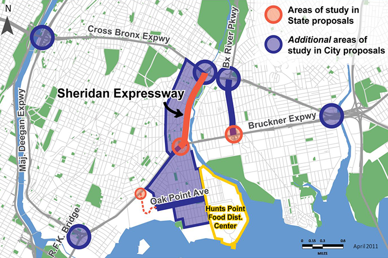
Sheridan-Hunts Point Land Use and Transportation Study

On December 10, 2013, the Department of City Planning (DCP), the Department of Transportation (DOT), Economic Development Corporation (EDC), Housing Preservation and Development (HPD) and the Mayor’s Office of Long Term Planning and Sustainability (OLTPS) released The Sheridan Expressway Study: Reconnecting the Neighborhoods Around the Sheridan Expressway and Improving Access to Hunts Point.
The Sheridan Expressway-Hunts Point Land Use and Transportation Study (SEHP) was a two-year intensive, interdisciplinary study of the neighborhoods and infrastructure surrounding the Sheridan Expressway, funded by a grant from USDOT. The study strikes a balance between an increasingly vibrant residential area and the need to maintain efficient routes traveling to Hunts Point Market, the economic and employment core of the area.
The proposals developed, and ultimately the final recommendations, were the result of close consultation with a broad range of stakeholders over a two year period. The study team worked to strike a balance between an increasingly vibrant residential area and the need to maintain efficient routes for traffic traveling to Hunts Point, the economic and employment core of the area.
The City’s recommended scenario, the Modify-Combined, supports decades of efforts to restore vitality to this section of the South Bronx. The City selected this scenario based on extensive data collection and analysis, state-of-the-art transportation modeling, comprehensive community engagement, and frequent meetings with elected officials, community organizations, and other stakeholders. The Modify-Combined scenario is endorsed by political leaders and community organizations as a solution to the decades-long dispute over the future of the Sheridan Expressway.
Why Modify the Sheridan Expressway?
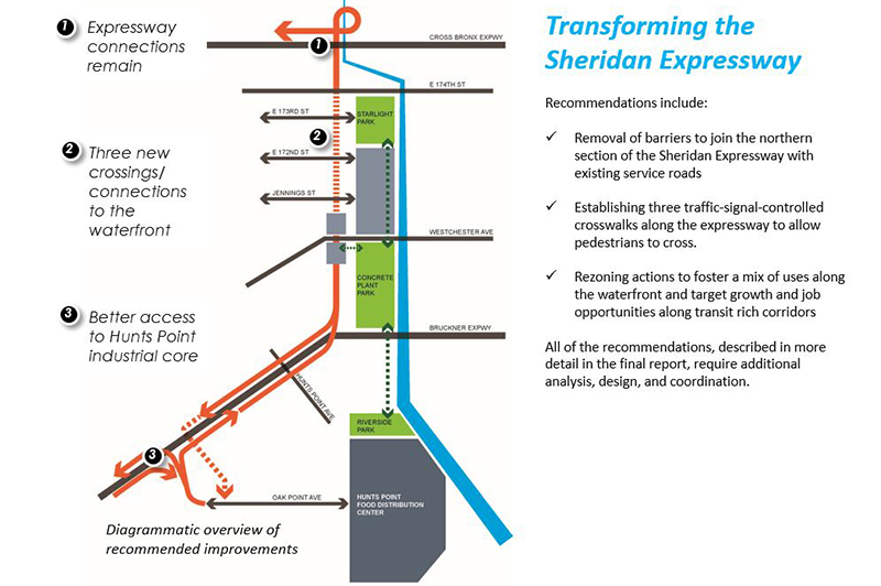
The study’s recommendations include improving public access to parks along the Bronx River currently cut off by the Expressway, increasing the safety of the pedestrian network, changing neighborhood zoning and improving the highway network. Implementation actions for the Department include zoning changes to encourage appropriate mixed-use development along Southern Boulevard and East Tremont Avenue, and, if recommended improvements to the at-grade portion of the Sheridan Expressway occur, a rezoning on waterfront sites along the Bronx River.

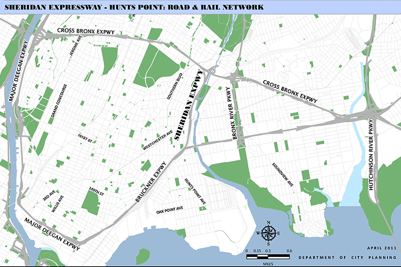
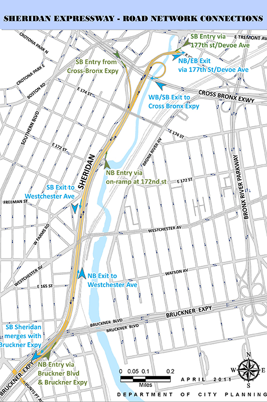
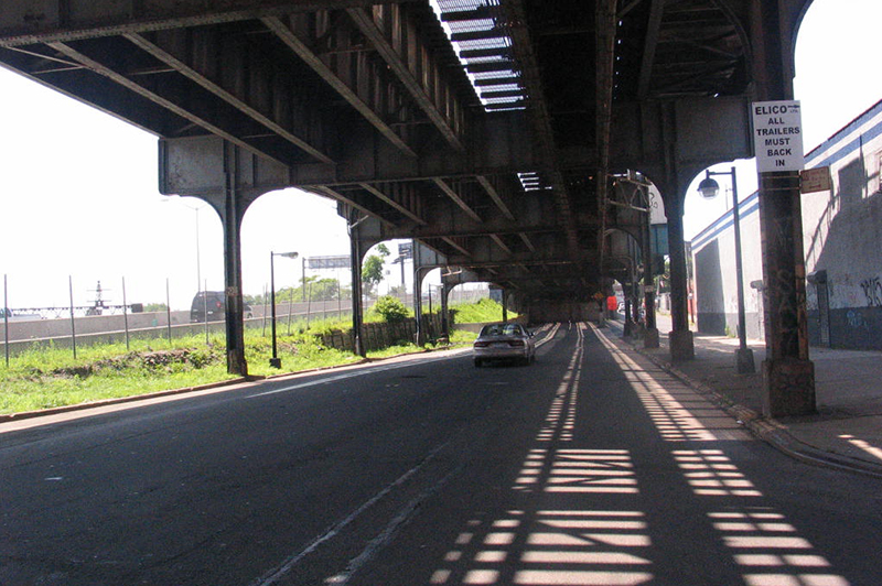
The Sheridan Expressway (I-895) in the Bronx links the Bruckner Expressway (I-278) at its southern end and the Cross Bronx Expressway (I-95) at its northern end. The Sheridan Expressway, which opened in 1963, is 1.25 miles long; however, when the expressway was originally planned in the 1940s , it was slated to extend northward through the Bronx Zoo and into Westchester County. In addition to automobile traffic, the Sheridan’s most critical use is the circulation of trucks between the nation’s major agricultural regions in the western and southern parts of the country and Hunts Point Food Distribution Center. The New York State Department of Transportation estimates that approximately 35,000 vehicles travelled daily on the Sheridan Expressway in 2009 in both directions. (Source: ![]() NYSDOT 2009 Traffic Data Report for New York State). The expressway has a number of limitations, including a limited number of interchanges and complicated intersections. The expressway can be entered southbound at an irregular intersection of local streets (177th Street and Devoe Avenue) and from a ramp off the Cross-Bronx Expressway. One northbound entrance to the expressway is via an on-ramp north of Hunts Point Avenue while the second entrance is via a ramp off the Bruckner Expressway.
NYSDOT 2009 Traffic Data Report for New York State). The expressway has a number of limitations, including a limited number of interchanges and complicated intersections. The expressway can be entered southbound at an irregular intersection of local streets (177th Street and Devoe Avenue) and from a ramp off the Cross-Bronx Expressway. One northbound entrance to the expressway is via an on-ramp north of Hunts Point Avenue while the second entrance is via a ramp off the Bruckner Expressway.
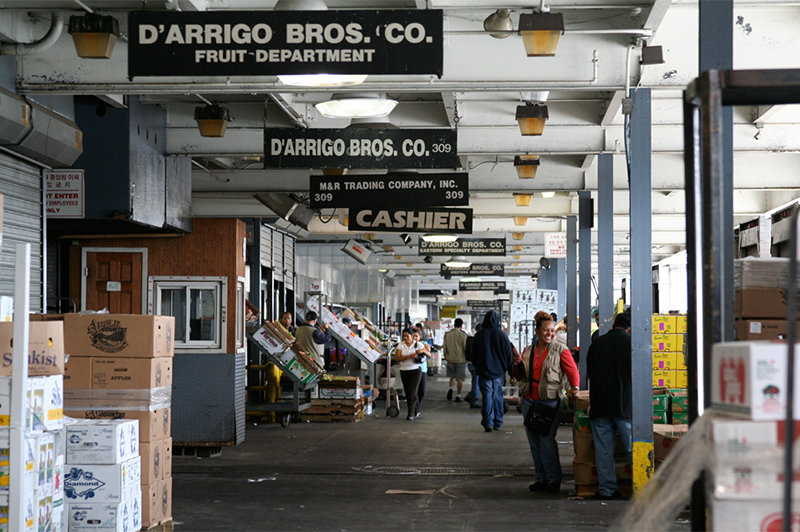
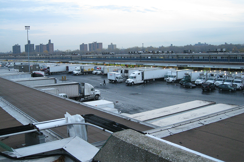
The area surrounding the Sheridan Expressway is diverse and complex. The Hunts Point Food Distribution Center (FDC) is a major user of the Sheridan Expressway and the entire highway network in the South Bronx. FDC, a 330-acre facility, is the largest wholesale food market in North America, providing food not only to the 22 million people who live in the New York region, but also the greater Mid-Atlantic and Northeast catchment area. The FDC directly employs 10,000 people in high-paying blue-collar jobs in over 115 firms, and indirectly employs tens of thousands of others, from spin-off adjacent food business and related industries that cluster near the FDC to agricultural growers across the country. The FDC includes three major cooperative markets (Hunts Point Produce Market, Hunts Point Cooperative Market and New Fulton Fish Market) as well as smaller wholesalers, food manufacturers and distributors, including Bazzini Nuts, Anheuser- Busch and Krasdale. Today, shippers face 8-13 hour delays accessing the FDC because of the need for trucks to travel on local streets, heavily congested highways, and inefficient layouts of local facilities. From a food access perspective, it is critical that the changes to the South Bronx's infrastructure improve access to FDC.
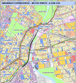
More than 200,000 people also live within a mile of the expressway. Multiple neighborhoods surround the Sheridan: Crotona Park to the west, West Farms to the north, Longwood and Hunts Point to the south, Bruckner and Soundview to the east. The expressway, despite its short length, runs through four community districts: 2, 3, 6, and 9. During the 1970s, the communities to the west of the expressway experienced the greatest population loss in the entire Bronx –a two-third population loss – but the area also saw some of the first signs of renewal in the 1980s and today Crotona Park East and Charlotte Gardens are stable residential communities. Bruckner and Soundview contain predominantly low-scale residences with some notable high-rise buildings such as Soundview Houses (NYCHA) north of Soundview Park. The Hunts Point peninsula to the south includes a stable residential population of approximately 11,000 amongst the industrial and food-related businesses. Immediately surrounding the Sheridan Expressway are light industrial uses, auto-repair shops, auto salvage yards, parking, warehouses, as well as a small motel, multiple schools, an MTA bus depot, apartment buildings, and three parks. With support from the City, more than 4,672 new affordable housing units have been developed in the vicinity of the expressway. The Bronx River runs parallel to the expressway to the east, and the elevated #6 subway line and regional rail/Amtrak line run along the expressway and cross it near Westchester Avenue.
Southern Boulevard, East Tremont Avenue, Westchester Avenue are all lively local commercial corridors in the vicinity of the Sheridan Expressway. The New Horizons Shopping Center on E 174thStreet and Bruckner Plaza in Soundview offer larger regional commercial establishments. The general area surrounding the Sheridan Expressway is well served by subways and buses. The 2 and 5 subway lines run north-south along Southern Boulevard with 5 subway stops within half mile of the Expressway and the 6 train running east-west with 3 subway stops within a half mile. Several bus routes operate along major streets in the area including 174thStreet (Bx 36), Southern Boulevard (Bx 19), West Farms Road (Bx 11, BxM 10, BxM11 and BxM 6), East Tremont Avenue (Bx 40 and Bx 42), E 180th Street (Bx9, Bx 36), Westchester Avenue ( Bx 4, Bx 4A and Bx 27), Bruckner Boulevard (Bx 5, BxM7, BxM 7A, BxM9 & BxM11) and Hunts Point Avenue (Bx 6).
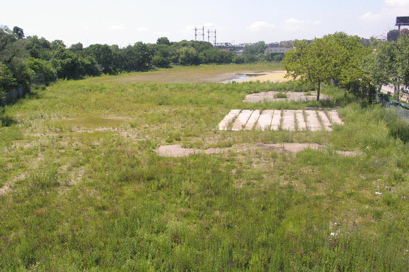
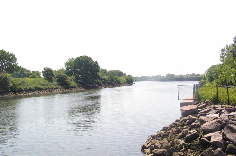
Future planning for the area will also require sensitivity to the natural resources in the area, the ongoing restoration efforts and the need to enhance access to the Bronx River and the greenway. The Bronx River flows along the eastern side of the Sheridan Expressway. From its origin at the Kensico Dam in Westchester County to the East River at Hunts Point, the Bronx River travels 23 miles and winds eight miles through the length of the Bronx. It is the only fresh water river in the City of New York. Until the 1830s, the Bronx River valley was lush with forests; however, the construction of the New York Central Railroad in the 1840s brought industrial uses to its bank which discharged waste into the river. The industrial past and increasing urban runoff resulted in degradation of the river’s water quality and shoreline. The Sheridan Expressway, first planned by Robert Moses in the 1940s, required rerouting the Bronx River.
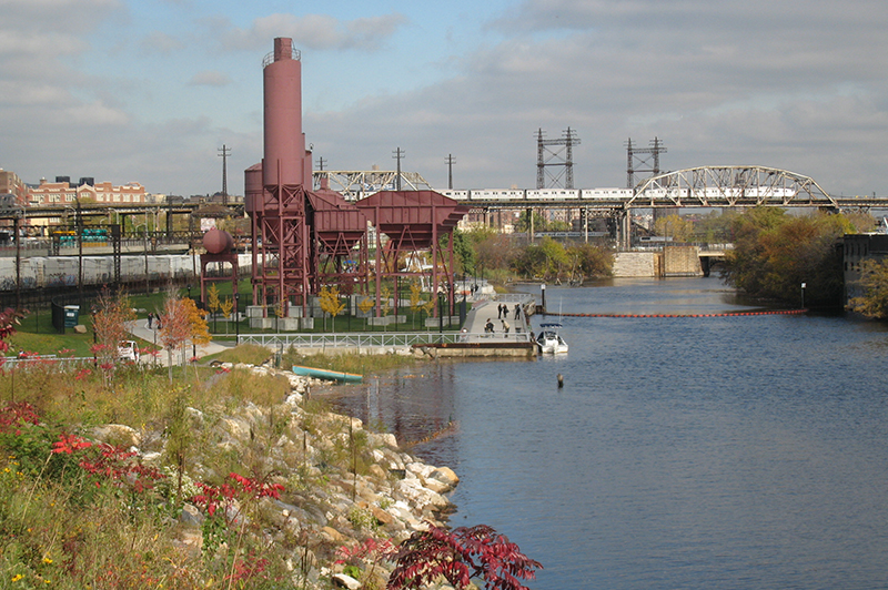
Efforts to clean up the river date back to the Bronx River Restoration Project incorporated in 1974. The main mission of the Bronx River Alliance, founded in 2001, is to protect, improve and restore the Bronx River corridor and its watershed. The Department of Parks and Recreation and the Bronx River Alliance released the Bronx River Greenway Plan in 2006 which aims to provide a continuous connection of parks along the Bronx River thus improving public access to the river. The greenway runs along the length of the Bronx River joining major open spaces throughout the borough, including Bronx Park (Bronx Zoo and New York Botanical Garden), Starlight Park (under construction by the New York State Department of Transportation), Concrete Plant Park (opened 2009), and Soundview Park.

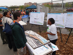
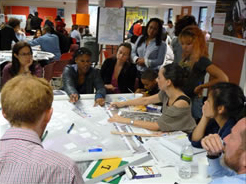
Beginning in June 2011, the City conducted an interdisciplinary planning process focused on creating a holistic vision for the Sheridan-Hunts Point area. The SEHP planning process involved the Office of the Deputy Mayor for Economic Development, the Department of City Planning, Department of Transportation, New York City Economic Development Corporation, Department of Housing Preservation and Development and the Mayor’s Office of Long Term Planning and Sustainability. Through public meetings and design charrettes and a Community Working Group, the study engaged the broader community and stakeholders.
A full range of engagement tools, including land-use planning exercises, charrettes, and site visits, were used to help community stakeholders gain a shared understanding of the existing conditions and challenges and consider how the community’s goals and needs could be met through multiple scenarios, including retention, redevelopment, or transformation of the Sheridan Expressway into a boulevard. The broader area beyond the Sheridan was considered and special attention given to improving access to Hunts Point. Local priorities were used to guide the planning process and ultimately form recommendations.
A key element of the City’s study was the collection of in depth information about area transportation and land use used to conduct analysis. The City’s analysis included:
- Traffic network analysis, including all of the critical elements of the road network that affect access to Hunts Point and other destinations in the study area.
- Hunts Point truck study, to gather up-to-date information on access to industrial areas including Hunts Point, a critical economic driver for the Bronx and the region.
- Land use analysis of the surrounding area and the options identified during the community visioning process
- A comprehensive sustainability analysis of different options
Community Engagement in the Planning Process
The Sheridan Expressway has been at the central of several studies and debate at the state and local level for over a decade. The Sheridan Expressway – Hunts Point Land Use and Transportation Study was an intensive two-year planning process aimed at aligning the land use and transportation needs and priorities of the City, local residents, the business community with those of the broader region. The process was grounded in the understanding that interagency cooperation and the engagement of a diverse group of stakeholders were crucial to comprehensive planning and consensus building.
A Community Working Group (CWG) was established to ensure that the diverse interests of the many neighborhoods in the large study area were represented in the process. The City also held a series of public meetings to provide information and solicit feedback on ideas, priorities and concerns. In addition to the public meetings, the City met frequently with representatives of Community Boards 2, 3, 6 and 9, hosted tours in the area, held open houses and hosted several other events including displays at The Point CDC and the Bronx River Arts Center.
For more information about the Sheridan Expressway Study please contact sheridan_hp@planning.nyc.gov.
The NYC Department of City Planning was invited to present work on the SEHP study as part of the Bronx River Arts Center exhibition series, Process and Progress: Engaging in Community Change,that highlights the Bronx River Art Center’s development during a time of significant structural and cultural change in the borough. The Department of City Planning presented a scale model of the Sheridan and its surrounding road network as well as collection of work illustrating the development of the study from ideas and research to final recommendations.

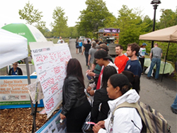
Integral to the success of the Sheridan-Hunts Point planning process is the active participation of a wide range of stakeholders. In addition to public site tours, the Department of City Planning will lead public design charrettes to actively engage stakeholders in planning the complex Sheridan-Hunts Point area.
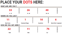
![]() View a full summary of the October 15, 2011 Planning Charrette.
View a full summary of the October 15, 2011 Planning Charrette.
In the summer of 2011, the Bronx office of the Department of City Planning led three public walking tours of the Sheridan Expressway-Hunts Point study area.
Public Meetings
Final Recommendations - June 25, 2013
After two years of community meetings, data gathering and analysis, the City's interagency team leading the Sheridan Expressway Land Use and Transportation Study presented final recommendations at the final public meeting.
Draft Recommendations - May 21,2013
On Tuesday, May 21st, 2013 the Interagency Team leading the SEHP process held a public meeting to share draft recommendations and a summary of analysis completed. The meeting was an opportunity for a broad discussion about how various analyses impacted the city’s decision making. View the informational displays that describe existing conditions, expressway redesign options and our planning framework.
Community Working Group (CWG) Meetings
- Draft Scenarios - March 7, 2013 -
 View the meeting Presentation
 - Hunts Point Land Use - November 27, 2012 - View the meeting Presentation
- SEHP Study Area Land Use - June 28, 2012 - View the meeting Presentation
- Traffic Screening Analysis - May 10, 2012 - View the meeting Presentation
- Review of Traffic Data - April 19, 2012 - View the meeting Presentation
- Charette Preparation - September 1st, 2011- View a summary of the meeting, View the meeting Presentation
- Introductory Meeting - June 28th, 2011 - View a summary of the meeting, View the meeting Presentation