
 Department of City Planning311Search all NYC.gov websites


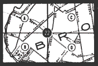
Zoning Maps
About the Maps
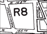
Zoning District Boundaries
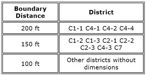
Each district is bounded by heavy solid lines. Where a boundary is not the centerline of a street, the distance between the boundary and street line (front lot line) is usually marked on the map. Where it is not marked, the boundary parallel to the long dimension of a block is the centerline of the block. Where the boundary is parallel to the short dimension of the block, the distance between the boundary and street line is as shown in the table below. (See Section 76-00 of the Zoning Resolution.)
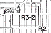
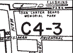
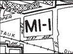
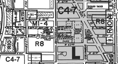
Note the zoning district in which the property is located. A letter identifies general use categories-R for residence districts, C for commercial districts and M for manufacturing districts. The first number after R generally indicates bulk and parking controls; the numbers after C or M refer to the range of permitted uses and, in most cases, bulk and parking controls.
Commercial Overlay Districts
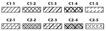
Commercial overlay districts are mapped within residence districts and designated by various patterns. A key to these patterns is shown here and on every zoning map.
Special Purpose Districts
Sketch Maps
When any portion of a zoning map would be affected by a recently adopted zoning change that has not yet been incorporated into the zoning map, or by a proposed zoning map change that has not yet been approved, the map is linked to a "sketch map" showing the specific changes adopted or proposed. A red rectangle on a zoning map indicates a recently adopted zoning change and a blue rectangle indicates a proposed zoning change. Selecting within the rectangle will display the relevant sketch map. Where there are overlapping sketch maps, dashed lines distinguish between maps.
Please note: If your Adobe Acrobat Reader is not configured properly, you may receive an error when attempting to view the sketch maps. Please see Technical Notes below for more information.
Technical Notes
All 126 zoning maps are in Adobe Acrobat format and range in size from 100k to over 700k. To view and print the maps, you will need the most recent version of the Adobe Acrobat Reader, available for free download.
Printing an entire map at the original scale (1"=1200') will require legal size paper. Acrobat Reader's Graphics Select tool and Copy tool can be used to copy and paste a portion of a zoning map at any scale into a word processing or graphics program.
To obtain the highest quality when printing sketch maps of proposed or adopted zoning, choose the "print as image" option on the Print screen.
If you receive an error when attempting to access the sketch maps, please ensure that your Adobe Acrobat Reader is configured to open within the browser (the default setting) and not in its own application window. The method for changing this setting varies by the version of your Acrobat Reader. For users of Acrobat 7.0, make sure that the 'Display PDF in Browser' checkbox setting (under Edit > Preferences > Internet) is checked.