
 Flood Maps311Search all NYC.gov websites
About FEMA Flood Maps

About FEMA Flood Maps
FEMA's FIRMs are not the Evacuation Maps, and often get confused. While both maps are important, they serve different purposes are telling you different information. An easy way to remember is: flood zones use letters to determine risk and evacuation zones use numbers to help you know when to evacuate. Find out more about Evacuation Maps at Know Your Zone.
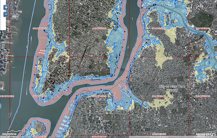
FEMA Flood Maps
FEMA creates Flood Insurance Rate Maps (FIRMs) that highlight flood risk and determine flood insurance and building code requirements. These maps identify areas that are at high risk to flooding. This high risk area has a one percent chance of flooding in any given year, and a twenty-six percent chance of flooding over the life of a thirty-year mortgage. This area is also referred to as the Special Flood Hazard Area (SFHA) or the 100-year floodplain, and is broken down into smaller areas called flood zones. Each flood zone tells homeowners what the risk is for flooding at their property. Find out more about understanding FEMA’s Flood Maps.
FEMA Flood Map Update
In January 2015, FEMA released Preliminary Flood Insurance Rate Maps for New York City as well as the Preliminary Flood Insurance Study (FIS) for New York City, a narrative report of the city’s flood hazard. The issuance of the Preliminary FIRMs and FIS marked the first step in the official flood map update process, which included a public comment and a 90-day technical appeals period.
In June 2015, New York City filed a technical appeal of the Preliminary FIRMs.
**In October 2016, FEMA announced that it agreed with the City’s findings,** and that it would work with the City to revise the 2015 Preliminary FIRMs and issue new maps in the coming years that better reflect current flood risk.
The City found technical and scientific errors in FEMA’s modeling that overestimate the height of flood waters during a one-percent-annual-chance flood event, the “Base Flood Elevation (BFE),” by between 1 and 2.5 feet across the city. As a result, FEMA’s modeling overestimates the size (or extent) of the one-percent-annual-chance (aka 100-year) floodplain (i.e., where waters will reach during a flood that has a one percent chance of occurring each year).
The City’s goal is to ensure FEMA’s Flood Insurance Rate Maps (FIRMs) provide residents with an accurate representation of the city’s current one percent annual flood risk (also known as the 100-year floodplain).
FEMA and City officials agreed that the information submitted during the appeal period will be used to revise the Preliminary Flood Insurance Study (FIS) and 2015 Preliminary FIRMs. In addition, FEMA and the City will work together to create a new methodology to incorporate the growing risks of climate change and sea level rise. This ground-breaking step will result in new flood maps that better account for the future risk of sea level rise and coastal storm surge for planning and building purposes, while protecting the affordability of flood insurance - which will continue to be priced against current flood risk.
In the meantime, to ensure that structures are constructed using the best available information, the New York City Building Code will continue to require new and substantially improved buildings to use the Preliminary FIRMs until a new map is created and adopted by the City.