

Projects & Design Toolkit
NYC DOT and the MTA are working together to advance near-term bus priority projects while laying the groundwork for more complex medium- and long-term initiatives.
On This Page
Current Projects
New York City is home to the largest bus priority program in North America. NYC DOT designs and builds bus priority infrastructure such as bus lanes and busways along priority corridors. These improvements provide dedicated space on the street for buses, enabling them to get through traffic more quickly and safely.
NYC DOT works in partnership with the MTA to implement street and signal changes that support improved bus service, while the MTA continuously monitors and adjusts routes and schedules for optimal performance. Where possible, NYC DOT and the MTA prioritize high-impact treatments including protected lanes, center-running facilities, and busways.
As part of the projects that support bus service, NYC DOT also installs a wide range of street safety features to protect pedestrians and micromobility users, while maintaining necessary vehicular access and simplifying traffic flow. To learn more about NYC DOT's full street design toolkit, please visit NYC DOT's Street Design Manual.
NYC DOT presents many street improvement projects at community board meetings to give the public an opportunity to ask questions and help shape outcomes. Current projects in development are listed below by borough. Find more NYC DOT street improvement projects and an archive of presentations for completed street redesigns on NYC DOT's Current Projects page and archive.
Bronx
Fordham Road, Major Deegan Expressway to Boston Road
NYC DOT is investigating transit improvements along Fordham Road between the Major Deegan Expressway and Boston Road. Fordham Road is a vital crosstown Bronx corridor. Nine bus routes (Bx9, Bx12 SBS/Local, Bx17, Bx22, Bx34, Bee-Line 60-62 buses) carry 93,700 daily riders, with connections to the A, B/D, 1, 2/5, 4, and 6 subways, and Metro North Harlem, Hudson, & New Haven Lines. In 2008, NYC DOT and MTA launched the first Select Bus Service (SBS) route on the Bx12, which included curbside bus lanes and off board fare payment. Between 2008 and 2014, Bx12 bus speeds and ridership increased. In recent years, bus speeds have declined, which has led to long, unreliable commutes and declining ridership. NYC DOT will evaluate a range of potential design improvements to improve bus speeds and reliability, while also improving curb management and traffic safety.
Fordham Road, Sedgwick Avenue to Bronx River Parkway - presented to Bronx Community Board 6 in May 2026 (pdf) Fordham Road, Sedgwick Avenue to Bronx River Parkway - presented to Bronx Community Board 7 in May 2026 (pdf) Fordham Road, Sedgwick Avenue to Bronx River Parkway - presented to Bronx Community Board 5 in May 2026 (pdf) Fordham Road, Inwood Bus Priority - presented to Bronx Community Board 6 in June 2023 (pdf) Fordham Road, Inwood Bus Priority - presented to Bronx Community Board 5 in June 2023 (pdf) Fordham Road, Inwood Bus Priority - presented to Bronx Community Board 11 in June 2023 (pdf) Fordham Road, Inwood Bus Priority - presented to Bronx Community Board 7 in June 2023 (pdf) Fordham Road, Inwood Bus Priority - presented to Fordham Road Community Advisory Board in May 2023 (pdf) Fordham Road, Inwood Bus Priority - presented to Fordham Road Community Advisory Board in March 2022 (pdf) Fordham Road, Major Deegan Expressway to Boston Road - presented at a public workshop in June 2021 (pdf) Fordham Road, Major Deegan Expressway to Boston Road - presented to Fordham Road Community Advisory Board in February 2021 (pdf) Fordham Road, Major Deegan Expressway to Boston Road - presented to Fordham Road Community Advisory Board in January 2021 (pdf)Grand Concourse, East 138th Street to Mosholu Parkway
NYC DOT is proposing bus priority treatments and safety improvements on Grand Concourse in the Bronx from East 138th Street to Mosholu Parkway. The Grand Concourse serves over 52,000 daily bus riders across the Bx1, Bx1 Limited, Bx2 and BxM4. Bus speeds are as slow as 5.5 miles per hour during the peak rush hour. The corridor serves several institutional sites such as Hostos Community College, Lincoln and BronxCare Hospitals, Yankee Stadium, Courthouses as well as multiple shopping districts. According to the US Census, 76% of area households do not own a vehicle and 73% commute via public transit or walking. Thirteen percent of area residents drive alone to work. Bus service is frequently slowed by double-parked cars and traffic congestion. Grand Concourse is a Vision Zero Priority Corridor, and NYC DOT will make additional safety investments along the corridor as part of this in-house Street Improvement Project.
Grand Concourse, East 138th Street to Mosholu Parkway - presented to Bronx Community Board 1 in September 2026 (pdf)Tremont Avenue, University Avenue to Bronx River Parkway
NYC DOT, in cooperation with MTA, is proposing bus priority improvements on Tremont Avenue in the Bronx to improve travel speed and reliability for nearly 34,000 daily bus riders on the Bronx’s 5th busiest bus route.
Learn more about the Tremont Avenue Busway
Tremont Avenue, University Avenue to Bronx River Parkway - Community Advisory Board Meeting in March 2025 (pdf) Tremont Avenue, University Avenue to Bronx River Parkway - presented to Bronx Community Board 6 in February 2025 (pdf) Tremont Avenue, University Avenue to Bronx River Parkway - presented to Bronx Community Board 6 in November 2024 (pdf) Tremont Avenue, University Avenue to Bronx River Parkway - presented to Bronx Community Board 5 in November 2024 (pdf) Tremont Avenue, University Avenue to Bronx River Parkway - Community Advisory Board Meeting in July 2024 (pdf) Tremont Avenue, University Avenue to Bronx River Parkway - presented to Bronx Community Board 6 in June 2024 (pdf) Tremont Avenue, University Avenue to Bronx River Parkway - presented to Bronx Community Board 5 in June 2024 (pdf) Tremont Avenue, University Avenue to Bronx River Parkway - presented to Bronx Community Board 5 in March 2024 (pdf) Tremont Avenue, University Avenue to Bronx River Parkway - presented to Bronx Community Board 6 in February 2024 (pdf) Tremont Avenue, University Avenue to Boston Road - Community Advisory Board Meeting 1 in December 2022 (pdf)Brooklyn
Bay Parkway and Cropsey Avenue
NYC DOT, in collaboration with the MTA, is proposing bus priority and safety improvements on Bay Parkway from Avenue J to Shore Parkway as well as Cropsey Avenue from Bay Parkway to 26th Avenue. This project aims to improve bus service and reliability for 35,000 daily bus riders on bus routes along the two corridors. These corridors were identified as a priority in the NYC Streets Plan and Brooklyn Bus Network Redesign, and Bay Parkway is a Vision Zero priority corridor.
Bay Parkway and Cropsey Avenue - presented to Brooklyn Community Board 12 in July 2026 (pdf) Bay Parkway and Cropsey Avenue - presented to Brooklyn Community Board 11 in June 2026 (pdf) Chinese (Traditional) | Bay Parkway 和Cropsey Avenue 公交車優先與安全改善最終方案 - 向第11、12 社區委員會及民選官員報告 - 2026 年6 月 (pdf) Arabic | Bay Parkway وشارع Cropsey المقترح النهائي لتحسين أولوية مرور الحافلات والسلامة عرض تقديمي لمجالس الأحياء 11 و 12 والمسؤولين المنتخبين يونيو 2026 (pdf) Russian | Bay Parkway и Cropsey Avenue Презентация для общественных советов 11 и 12, а также для выборных должностных лиц Июнь 2026 г. (pdf) Spanish | Bay Parkway y Cropsey Avenue - Presentación ante Juntas Comunitarias11, 12 y Funcionarios Electos en Junio 2026 (pdf) Bay Parkway and Cropsey Avenue - presented to Brooklyn Community Board 12 in June 2025 (pdf) Bay Parkway and Cropsey Avenue - presented to Brooklyn Community Board 11 in June 2025 (pdf) Bay Parkway and Cropsey Avenue - presented to Brooklyn Community Board 12 in January 2025 (pdf) Bay Parkway and Cropsey Avenue - presented to Brooklyn Community Board 11 in November 2024 (pdf)Dekalb & Lafayette Avenues
NYC DOT and MTA seek to improve B38 bus service and pedestrian and cyclist safety on Dekalb and Lafayette Avenues. Various treatments will be studied to find the best balance of all modes on these important connections across Brooklyn and into Queens.
Dekalb & Lafayette Avenues - presented to Brooklyn Community Board 3 in September 2026 (pdf) Dekalb & Lafayette Avenues - presented to Brooklyn Community Board 2 in September 2026 (pdf) Dekalb & Lafayette Avenues - presented to Brooklyn Community Board 2 in December 2024 (pdf) Dekalb & Lafayette Avenues - presented to Brooklyn Community Board 3 in December 2024 (pdf)Eastern Parkway, Schenectady Avenue to Ralph Avenue
NYC DOT, in collaboration with MTA, is proposing accessibility improvements along Eastern Parkway, from Schenectady Avenue to Ralph Avenue. The proposal aims to create ADA-accessible ramps and bus stops, as well as improve B14 reliability along Eastern Parkway.
Eastern Parkway, Schenectady Avenue to Ralph Avenue - presented to Brooklyn Community Board 8 in April 2025 (pdf) Eastern Parkway, Schenectady Avenue to Ralph Avenue - presented to Brooklyn Community Board 9 in April 2025 (pdf) Eastern Parkway, Schenectady Avenue to Ralph Avenue - presented to Brooklyn Community Board 8 in March 2025 (pdf)Central Brooklyn: Church Avenue, Flatbush Avenue, and Utica Avenue
NYC DOT and MTA are planning near-term and long-term rapid bus and complete street improvements on three critical, high-ridership, Vision Zero corridors in Central Brooklyn: Church Avenue, Flatbush Avenue, and Utica Avenue. These corridors serve over 150,000 bus riders on 13 bus routes each day. In 2026, NYC DOT and MTA began project coordination and community engagement along these corridors.
Learn more about the Central Brooklyn: Church Avenue, Flatbush Avenue, and Utica Avenue projectFlatbush Avenue, Livingston Street to Avenue V
NYC DOT, in cooperation with MTA, is implementing center-running bus lanes on Flatbush Avenue between Livingston Street and Grand Army that will deliver faster, more reliable commutes for 69,000 daily riders on 6 routes. NYCDOT and MTA are currently gathering feedback and planning for bus priority and pedestrian safety improvements on Flatbush Avenue between Grand Army Plaza and Avenue V. The future plans will be informed by a robust community engagement process.
Flatbush Avenue, State Street to Grand Army Plaza - Street Design Checklist (pdf) Flatbush Avenue, State Street to Grand Army Plaza - Major Transportation Project Briefing - April 2026 (pdf) Flatbush Avenue, Livingston Street to Avenue V - presented to Brooklyn Community Board 6 in October 2025 (pdf) Flatbush Avenue, Livingston Street to Avenue V - presented to Brooklyn Community Board 8 in October 2025 (pdf) Flatbush Avenue, Livingston Street to Avenue V - presented to Brooklyn Community Board 2 in September 2025 (pdf) Flatbush Avenue, Livingston Street to Avenue V - Community Advisory Board Meeting in July 2025 (pdf) Flatbush Avenue, Livingston Street to Avenue V - presented to Brooklyn Community Board 8 in June 2025 (pdf) Flatbush Avenue, Livingston Street to Avenue V - presented to Brooklyn Community Board 6’s Transportation Committee in June 2025 (pdf) Flatbush Avenue, Livingston Street to Avenue V - presented to Brooklyn Community Board 2 in June 2025 (pdf) Flatbush Avenue, Livingston Street to Avenue V - presented to Brooklyn Community Board 6 in June 2024 (pdf) Flatbush Avenue, Livingston Street to Avenue V - presented to Brooklyn Community Board 8 in June 2024 (pdf) Flatbush Avenue, Livingston Street to Avenue V - presented to Brooklyn Community Board 2 in June 2024 (pdf) Flatbush Avenue, Livingston Street to Avenue V - Community Advisory Board Meeting in June 2024 (pdf) Flatbush Avenue, Livingston Street to Avenue V - presented to Brooklyn Community Board 14 Transportation Committee in January 2023 (pdf) Flatbush Avenue, Livingston Street to Avenue V - Community Advisory Board Meeting in November 2022 (pdf) Flatbush Avenue, Livingston Street to Avenue V - presented to Brooklyn Community Board 9 Transportation Committee in September 2022 (pdf) Flatbush Avenue, Livingston Street to Avenue V - June 2022 Kickoff Meeting (pdf)Linden Boulevard, Fountain Avenue to Conduit Avenue
NYC DOT is proposing bus priority and traffic safety improvements on Linden Boulevard in Brooklyn and Queens from Fountain Avenue to Conduit Avenue. This project seeks to improve bus service for 38,000 bus passengers using four bus routes on this Vision Zero corridor.
Linden Boulevard, Fountain Avenue to Conduit Avenue - presented to Brooklyn Community Board 5 in April 2026 (pdf) Linden Boulevard, Fountain Avenue to Conduit Avenue - presented to Brooklyn Community Board 5 in January 2025 (pdf)Livingston Street Phase 2
NYC DOT, in collaboration with MTA, is proposing bus lanes improvements on Livingston Street, from Hoyt Street to Boerum Place, and Joralemon Street, from Boerum Place to Court Street. The proposal also includes protected bike lanes on Livingston Street, between Court Street and Boerum Place, to improve future bike network connections.
Livingston Street Phase 2 - presented to Brooklyn Community Board 2 in September 2026 (pdf)Marcy Avenue, Borinquen Place to Broadway
NYC DOT recently installed a bus priority lane along the three blocks of Marcy Avenue between Borinquen Place and Broadway. These three blocks host a confluence of three Williamsburg Bridge/Washington Plaza-bound bus routes: the B24, B60, and Q54, and each route experiences delays and slower speeds along this tail end stretch. These delays compound on top of delays earlier in the routes’ journeys and result in buses arriving late to their terminal, delaying the next scheduled run. NYC DOT installed a bus priority lane along these three blocks of Marcy Avenue to help alleviate these delays and is monitoring and evaluating its impact through the end of the year.
Marcy Avenue, Borinquen Place to Broadway - presented to Brooklyn Community Board 1 in September 2025 (pdf) Marcy Avenue, Borinquen Place to Broadway - presented to Brooklyn Community Board 1 in June 2025 (pdf)Manhattan
116th Street, Morningside Avenue to Pleasant Avenue
NYC DOT is studying bus priority and pedestrian safety improvements on 116th Street, Manhattan Avenue, Morningside Avenue and Pleasant Avenue in Manhattan. The 116th Street Study Area serves 10 bus routes (M3, M7, M102, M116, BxM1, BxM6, BxM7, BxM8, BxM9, BxM11), which carry 65,000+ daily riders, with connections to the 2, 3, 6, B, C trains and seven perpendicular bus routes. The study area experiences slow bus speeds, with buses traveling less than 4 mph in some segments. Weekday congestion causes 785 hours of delay to M116 passengers daily. 116th Street is a Vision Zero Priority Corridor, within a Priority Youth Injury Area and Senior Area. NYC DOT aims to improve safety through organizing the roadway, improving visibility and predictability, slowing turning vehicles, and creating safer crossings.
116th Street, Morningside Avenue to Pleasant Avenue - Street Design Checklist (pdf) 116th Street, Morningside Avenue to Pleasant Avenue - presented to Manhattan Community Board 11 in June 2026 (pdf) 116th Street, Morningside Avenue to Pleasant Avenue - presented to Manhattan Community Board 11 in June 2025 (pdf) 116th Street, Morningside Avenue to Pleasant Avenue - presented to Manhattan Community Board 10 in June 2025 (pdf) 116th Street, Morningside Avenue to Pleasant Avenue - presented to Manhattan Community Board 9 in June 2025 (pdf) 116th Street, Morningside Avenue to Pleasant Avenue - presented to Manhattan Community Board 11 in May 2025 (pdf) 116th Street, Morningside Avenue to Pleasant Avenue - presented to Manhattan Community Board 10 in May 2025 (pdf) 116th Street, Morningside Avenue to Pleasant Avenue - presented to Manhattan Community Board 11 in March 2025 (pdf) 116th Street, Morningside Avenue to Pleasant Avenue - presented to Manhattan Community Board 10 in February 2025 (pdf) 116th Street, Morningside Avenue to Pleasant Avenue - presented to Manhattan Community Board 9 in February 2025 (pdf)34th Street, 12th Avenue to FDR Drive
NYC DOT, in collaboration with MTA, is exploring bus and pedestrian safety enhancements on 34th Street. Located within the Congestion Pricing tolling zone, 34th Street has been identified as an important corridor for facilitating safe and easy travel within the Central Business District. The project aims to improve bus speeds and reliability, and safety for the corridor's thousands of daily bus riders and pedestrians.
Learn more about the 34th Street Busway
34th Street, 12th Avenue to FDR Drive - presented to Manhattan Community Board 6 in June 2025 (pdf) 34th Street, 12th Avenue to FDR Drive - presented to Manhattan Community Board 4 in May 2025 (pdf) 34th Street, 12th Avenue to FDR Drive - presented to Manhattan Community Board 5 in May 2025 (pdf) 34th Street, 12th Avenue to FDR Drive - presented to Manhattan Community Board 6 in February 2025 (pdf) 34th Street, 12th Avenue to FDR Drive - presented to Manhattan Community Board 5 in January 2025 (pdf) 34th Street, 12th Avenue to FDR Drive - presented to Manhattan Community Board 4 in January 2025 (pdf)79th Street, Riverside Drive to FDR Drive
NYC DOT is planning to install transit and pedestrian safety improvements along 79th Street from Riverside Drive to the FDR Drive as part of the 79th Street SBS Capital Project. This capital project follows up on NYC DOT’s 2017 Street Improvement Project (SIP) that was implemented as part of the launch of the M79 Select Bus Service. Improvements made by this capital projects will include bus bulbs, upgraded bus stops, new bus pads, updated ADA elements, curb extensions, improved median pedestrian refuges, refurbished sidewalks, stormwater infiltration basins, and new landscaping. The safety benefits of the project will include increased pedestrian visibility and accessibility, shorter and safer pedestrian crossings, and slower and safer vehicle turns. The transit benefits of the projects include the provision for faster boarding and alighting times, improved bus reliability, and new bus stop amenities.
79th Street, Riverside Drive to FDR Drive - presented to Manhattan Community Board 7 in April 2025 (pdf) 79th Street, Riverside Drive to FDR Drive - presented to Manhattan Community Board 8 in April 2025 (pdf)Broadway, 157th Steet to 220th Street
NYC DOT is exploring a potential project on Broadway between 157th and 220th St in cooperation with MTA. This section of Broadway has been identified by the NYC Streets Plan. The study will identify ways to improve bus speeds and reliability on the corridor, as well as general safety and traffic flow improvements.
Broadway, 157th Steet to 220th Street - presented to Manhattan Community Board 12 in March 2025 (pdf)Lexington Avenue, 60th Street to 52nd Street
NYC DOT proposes converting the existing curbside bus lane into an offset bus lane on this eight-block stretch. Moving the bus lane away from the curb, will reduce conflict between buses and other vehicles trying to access the curb, and improve bus operations.
Lexington Avenue, 60th Street to 52nd Street - presented to Manhattan Community Board 8 in October 2025 (pdf) Lexington Avenue, 60th Street to 52nd Street - presented to Manhattan Community Board 6 in October 2025 (pdf) Lexington Avenue, 60th Street to 52nd Street - presented to Manhattan Community Board 5 in September 2025 (pdf)Madison Avenue, East 23rd to 42nd Street
NYC DOT, in collaboration with MTA, is currently installing bus priority improvements on Madison Avenue from East 23rd Street to East 42nd Street. The proposal aims to improve bus speeds and reliability for 92,000 daily bus riders on 34 local and express bus routes that traverse the corridor. Improvements include extending the existing double bus lanes on Madison Avenue north of East 42nd Street south to East 23rd Street, left turn bays at select cross streets, and curb regulation changes.
Madison Avenue, East 23rd to 42nd Street - presented to Manhattan Community Board 6 in June 2025 (pdf) Madison Avenue, East 23rd to 42nd Street - presented to Manhattan Community Board 5 in May 2025 (pdf)Sixth Avenue, Watts Street to West 59th Street
NYC DOT is proposing bus priority, bicycle, and pedestrian improvements along 6th Avenue. The proposal would install bus lanes from Watts Street to 58th Street, improving bus speeds and reliability for 51,000 average daily riders on 4 Local and 27 Express MTA bus routes. This project also proposes to extend the bike lane widening from 35th Street to 59th Street and add left-turn calming treatments, further enhancing safety and comfort for cyclists and pedestrians.
Sixth Avenue, Watts Street to West 59th Street - presented to Manhattan Community Board 2 in June 2026 (pdf) Sixth Avenue, Watts Street to West 59th Street - presented to Manhattan Community Board 5 in June 2026 (pdf) Sixth Avenue, Watts Street to West 59th Street - presented to Manhattan Community Board 4 in June 2026 (pdf)Queens
Broadway, 69th Street to Roosevelt Avenue
NYC DOT, in coordination with the MTA and the Port Authority of New York and New Jersey, recently installed an eastbound center-running bus lane on Broadway in Queens between 69th Street and Roosevelt Avenue. The bus lane will speed up bus service for approximately 9,000 daily riders on the Q70 SBS and provide improved transportation from LaGuardia Airport to the Jackson Heights – Roosevelt Avenue subway station and bus terminal.
Broadway, 69th Street to Roosevelt Avenue - Street Design Checklist (pdf) Broadway, 69th Street to Roosevelt Avenue - presented to Queens Community Board 3 in May 2026 (pdf)Grand Street/Grand Avenue, Metropolitan Avenue to Queens Boulevard
NYC DOT, in collaboration with MTA, is proposing safety and bus priority improvements on Grand Street/Grand Avenue between Metropolitan Avenue and Queens Boulevard. Grand Street/Grand Avenue is a Vision Zero priority corridor that serves over 51,000 daily bus riders on the Q54, Q58, and Q59 bus routes.
Grand Street/Grand Avenue, Metropolitan Avenue to Queens Boulevard - presented to Queens Community Board 5 in December 2024 (pdf) Grand Street/Grand Avenue, Metropolitan Avenue to Queens Boulevard - presented to Queens Community Board 4 in November 2024 (pdf) Grand Street/Grand Avenue, Metropolitan Avenue to Queens Boulevard - presented to Brooklyn Community Board 1 in November 2024 (pdf)Staten Island
Victory Boulevard, Bay Street to Wild Avenue
NYC DOT and MTA seek to improve bus service and safety for all mode users on Victory Boulevard on Staten Island. Various treatments will be studied to find the best balance of all modes on these important connections across Staten Island.
Victory Boulevard, Wild Avenue to Willowbrook Avenue - presented to Staten Island Community Board 2 in June 2025 (pdf) Victory Boulevard, Bay Street to Little Clove Road - presented to Staten Island Community Board 1 in May 2025 (pdf) Victory Boulevard, Bay Street to Wild Avenue - presented to Staten Island Community Board 1 in March 2025 (pdf)Bus Lanes and Busways
The most visible elements of New York City's bus priority program are the bus lanes and busways that provide dedicated space on the street for buses. The types of bus lanes that NYC DOT designs and installs are summarized below.
Learn about bus lane rules on the Enforcement page.
Visit NYC Open Data for a list and map of bus lane locations and hours of operations and a list and map of RTPI sign locations.
Curbside Bus Lane
A curbside bus lane is a dedicated travel lane for buses that are designed to run along the travel lane directly adjacent to the curb and are delineated with pavement markings and signs.
Offset Bus Lane
An offset bus lane is a dedicated travel lane for buses that uses the travel lane adjacent to the parking or curb lane (i.e. offset from the curb lane).
Median Bus Lane
A median bus lane is a dedicated travel lane for buses designed to run in the middle of the street either along the curb of a median or the center of the street.
Busways
Busways are corridors that prioritize buses, trucks, emergency vehicles, and paratransit vehicles are called busways. These corridors are painted red and feature signage to designate buses through-access and inform other vehicles when they must exit or may enter the corridor. Busways make streets safer and more efficient and clear the way for faster trips.
Learn about busways in development in the Current Projects section above or find information about active busway corridors on the Busways page.
Select Bus Service
Select Bus Service is New York City's version of Bus Rapid Transit: an improved bus service that offers fast, frequent, and reliable service on high-ridership bus routes. Completed in much less time and at much lower cost than subways—which take years to construct and require expensive up-front infrastructure and equipment—Select Bus Service offers a more immediate improvement to New York City’s transit network benefitting the entire city through improved mobility, cleaner air, reduced greenhouse gas emissions, and reduced congestion.
Designed to provide rail-like service, Select Bus Service uses techniques and technologies such as dedicated bus lanes, off-board fare collection and transit signal priority to improve the quality and performance of transit and, in turn, to improve mobility and access in the neighborhoods that it serves.
Select Bus Service projects are also designed to make bus service easier to use, through features like bus bulbs, and high quality passenger information and overall attention to pedestrian and vehicular safety. Select Bus Service features can also be applied individually in locations not appropriate for the full Select Bus Service treatment.
Signal Innovation
Intersections are one of the most significant contributors to slow bus services. Our signals toolkit includes Transit Signal Priority and queue jump signals.
Transit Signal Priority
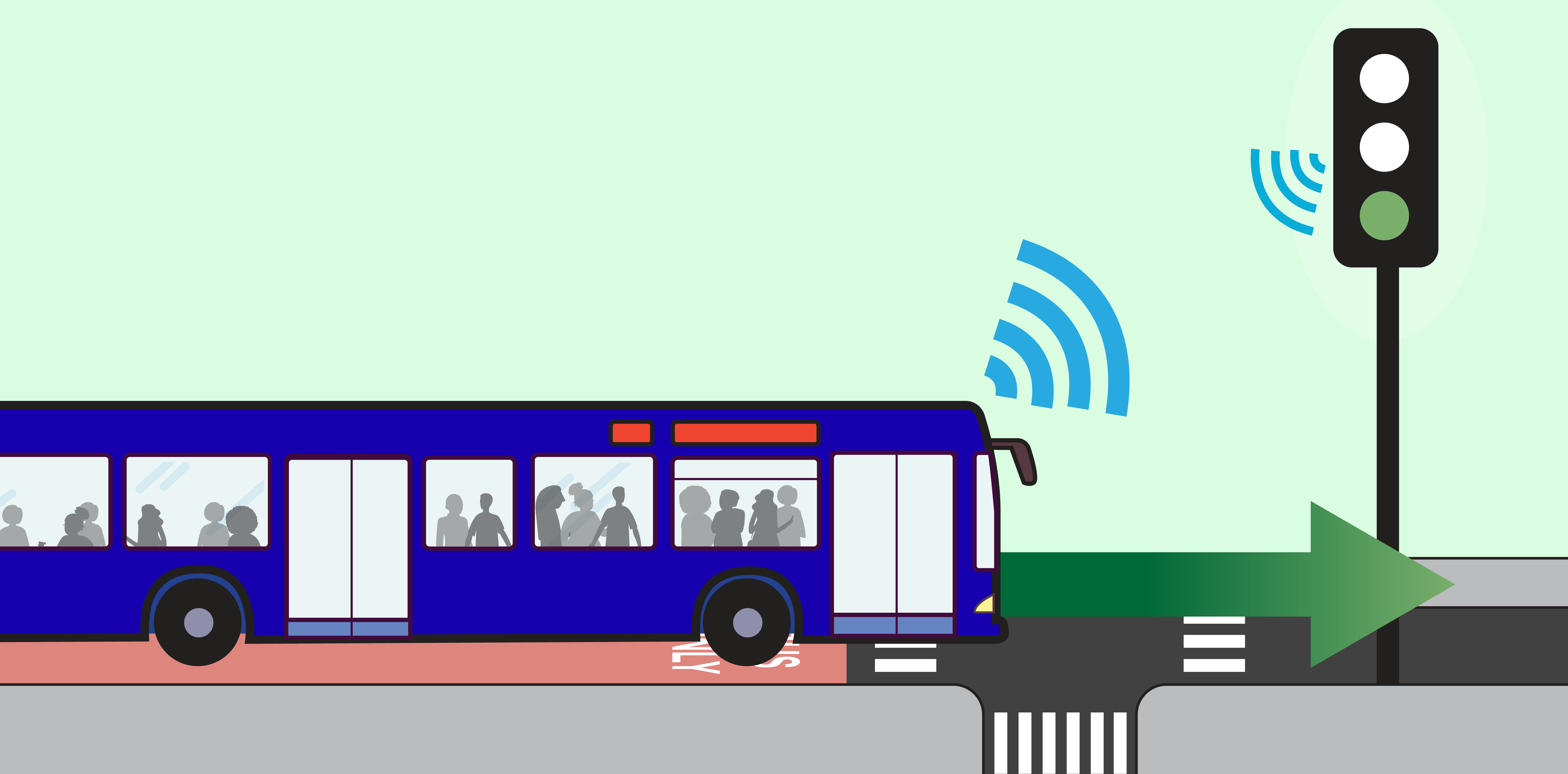
Transit Signal Priority (TSP) reduces the time buses spend at red lights. With TSP, buses signal the approaching traffic light to stay green longer, reducing wait times at intersections.
Queue Jumps
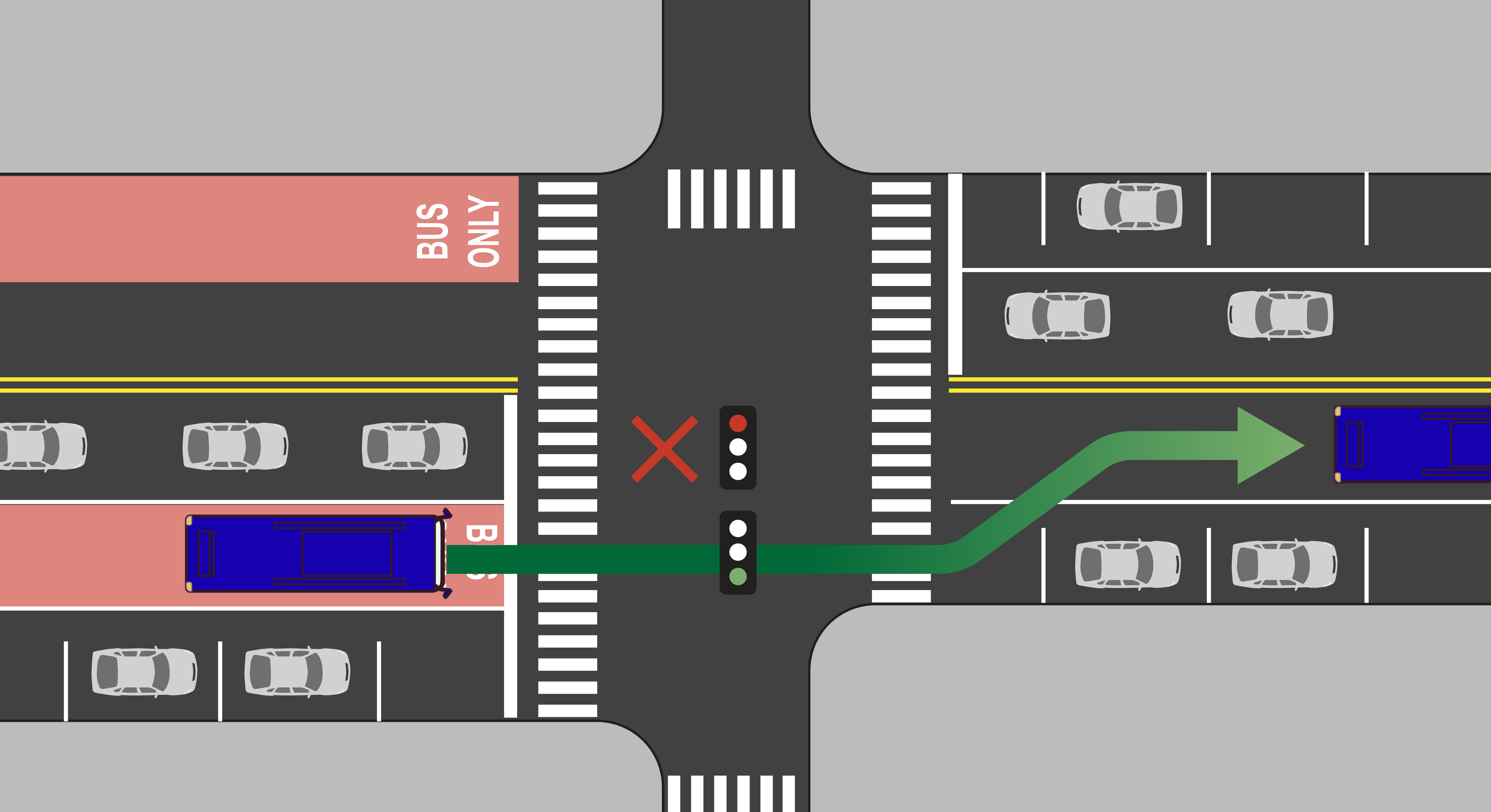
A queue jump is a dedicated signal for the bus, which gives the bus a headstart over vehicles waiting at red lights and allows the bus to bypass general traffic.
Rapid Bus Corridors
Rapid bus corridors will deliver fast and reliable service through transformative Bus Rapid Transit-style street design and enhanced stations with high-quality amenities. Building on nearly two decades of Select Bus Service, these corridors represent the next evolution in bus rapid transit for NYC

Rapid Bus Features
Building upon the improvements the existing Select Bus Service (SBS) rapid bus transit service has made, NYC DOT and the MTA will introduce new rapid bus transit features on NYC streets to:
- Provide high-frequency service throughout the day, every day: Makes bus travel more convenient and reliable by better accommodating transit demand throughout the day, reducing bus passenger waiting times, and decreasing crowding on buses.
- Create longer spacing between bus stops: Help buses travel faster by allowing them to make fewer and less frequent stops.
- Create fully separated bus lanes: When buses have their own lane on a roadway, they encounter fewer obstructions and travel faster.
- Give buses priority at intersections: Allow buses to travel through intersections ahead of other vehicles to minimize obstructions by crossing traffic and decrease the time that buses wait at traffic signals.
- Level boarding at bus stops: Raised bus stops allows passengers to enter and exit the bus without having to climb stairs nor navigate gaps, greatly improving accessibility for all users while also speeding up the boarding and alighting process.
- Enhanced bus stops: Improve the bus passenger experience by investing in the public realm and accessibility elements of a bus stop; including extensive seating, greenery, and other high-quality passenger amenities.
Rapid Bus Corridors In Development
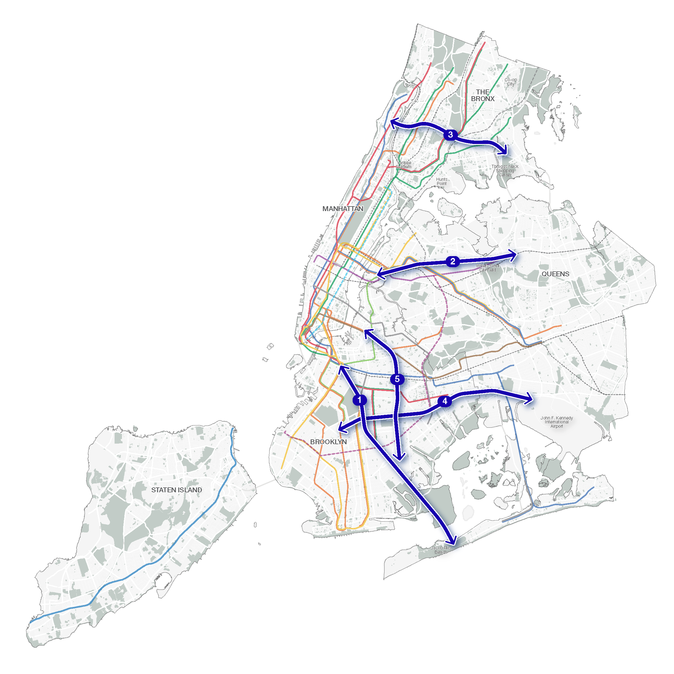
Rapid bus corridors are implemented through a combination of short-term and long-term projects, which will include quick-build street improvement projects as well as capital projects. The scope, duration, and timeline for each corridor project will vary.
Together, NYC DOT and MTA will collaborate and work closely with communities to develop implementation strategies for each corridor:
- Flatbush Avenue, Brooklyn
- Kensington-JFK, Brooklyn-Queens
- Utica Avenue, Brooklyn
- Northern Boulevard, Queens
- Tremont/Cross Bronx, Bronx