|
| ||
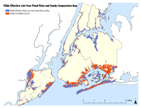
Understanding the Risk: Prior to Sandy, FEMA’s maps had not been updated since 1983 and understated the risk in many areas
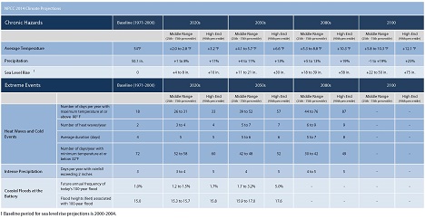
Source: FEMA and SIRR Floodplain elevations FEMA, a federal agency, last produced Flood Insurance Rate Maps (FIRMs) for the City in 1983 and was in the process of updating these maps prior to Sandy. On December 5, 2013, FEMA released Preliminary FIRMs for New York City as well as the Preliminary Flood Insurance Study (FIS), a narrative report of the City’s flood hazard. The issuance of the Preliminary FIRMs and FIS marks the first step in the regulatory review process which includes a public comment period followed by a statutory 90-day appeals period before the maps are adopted by the City. These maps and study replace FEMA’s interim Preliminary Work Maps that were released in June 2013 to inform rebuilding post-Hurricane Sandy. Please visit the official FEMA website about Preliminary Work Maps for more information: http://www.region2coastal.com/bestdata What is likely to happen in the future as climate changes and severe weather increases? While the City is working with FEMA to make sure the updated maps are the most accurate possible, merely understanding current risk is not enough. We must also understand the long-term risks facing the city. Therefore, a main directive of SIRR was to analyze the impacts of extreme events and long-term changes in climate on infrastructure, buildings, and the economy over the medium term (2020s) and long term (2050s) as informed by the latest scientific research. The first New York City Panel on Climate Change (NPCC1) was convened in 2008 to help respond to climate change in New York City and accomplish the goals outlined in PlaNYC, the City’s long-term sustainability plan. The NPCC – a body of leading climate and social scientists and risk management experts – was charged with advising the New York City Climate Change Adaptation Task Force on issues related to climate change and adaptation. It produced a set of climate projections specific to New York City. In September 2012, the City passed Local Law 42 that established the New York City Panel on Climate Change as an ongoing body. The NPCC is required to meet at least twice a year to: review recent scientific data on climate change and its potential impacts; make recommendations for projections for the 2020s, 2050s, and 2080s within one year of the publication of the IPCC Assessment Reports or at least every three years; and advise the City’s Office of Long-term Planning and Sustainability (OLTPS) on a communications strategy related to climate science. Following Hurricane Sandy, the City convened Second New York City Panel on Climate Change (NPCC2) in January 2013 to provide up-to-date scientific information and analyses on climate risks for use in the Special Initiative on Rebuilding and Resiliency (SIRR). In response to the charge to the panel, the NPCC developed new climate change projections and future coastal flood risk maps for New York City. This climate risk information is designed to inform community rebuilding plans as well as increase current and future resiliency of communities and citywide systems and infrastructure to a range of climate risks. These findings were released as part of SIRR’s report, A Stronger, More Resilient New York, and in a separate report entitled 2013 Climate Risk Information. The 2013 Climate Risk Information presents quantitative and qualitative information about future climate hazards, focusing on temperature, precipitation, and sea level. In December 2013, the NPCC released updated projections for the 2080s and 2100. You can access the report and the updated projections directly on the PlaNYC website. A summary of the latest projections detailed in 2013 Climate Risk Information and the updated materials can be found below.
| ||
 |